IMAGES TAKEN NEAR TO
BANFF, AB45 2JD
Introduction
This page details the photographs taken nearby to AB45 2JD by members of the Geograph project.
The Geograph project started in 2005 with the aim of publishing, organising and preserving representative images for every square kilometre of Great Britain, Ireland and the Isle of Man.

There are currently over 7.5m images from over14,400 individuals and you can help contribute to the project by visiting https://www.geograph.org.uk
Image Map
Images are licensed for reuse under creativecommons.org/licenses/by-sa/2.0
Notes
- Clicking on the map will re-center to the selected point.
- The higher the marker number, the further away the image location is from the centre of the postcode.
Image Listing (29 Images Found)
Images are licensed for reuse under creativecommons.org/licenses/by-sa/2.0
Image
Details
Distance
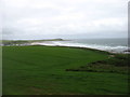
2
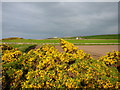
Field above Boyndie Bay
Looking in the direction of Whitehills.
Image: © Carron K
Taken: 15 Aug 2015
0.11 miles
4
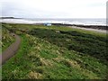
Golf Club House Railway Halt (site), Aberdeenshire
Opened in 1913 by the Great North of Scotland Railway on the line from Tillynaught to Banff, this station closed in 1964.
View north west towards Bridgefoot Halt and Tillynaught from an adjacent footpath, the former railway line can be seen running top left to bottom right. The halt site was right in the middle of the image. The golf clubhouse was almost adjacent to it but has similarly disappeared.
Image: © Nigel Thompson
Taken: 5 Sep 2019
0.15 miles
5
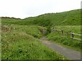
Bridge remains, Banff Links
Carrying the former branch railway to Banff over a path which appears to have been access to a golf course. The 1902 OS 25-inch mapping shows a club house immediately to the left of the bridge.
Image: © Alan Murray-Rust
Taken: 23 May 2022
0.15 miles
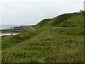
6
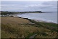
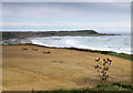
Path down to the shore from A98 near Banff
With distant views across Boyndie Bay to Whitehills (church on left horizon), and The Knock stretching out to sea on the right.
Image: © Stanley Howe
Taken: 10 Sep 2012
0.16 miles
7
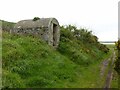
Small building on Banff links
I wondered at the time whether this was a platelayers hut adjacent to the former railway line. However it appears to have been an ammunition store for the Banffshire 'Terriers' who trained on the Banff links. It dates from c.1900 and is Listed Category C.
Image: © Alan Murray-Rust
Taken: 23 May 2022
0.16 miles
8
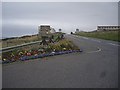
Layby on A98 at entrance to Banff from the west
Boyndie Road, with an hotel on the right.
Image: © Stanley Howe
Taken: 10 Sep 2012
0.17 miles
9
Farmland west of Banff
Looking towards Knock Head.
Image: © David Purchase
Taken: 11 Jun 2019
0.17 miles
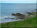
10
Banff Links
The platform at the base of the cliffs is the line of the branch railway to Banff which closed in 1968.
Image: © Alan Murray-Rust
Taken: 23 May 2022
0.18 miles