IMAGES TAKEN NEAR TO
BANFF, AB45 2EN
Introduction
This page details the photographs taken nearby to AB45 2EN by members of the Geograph project.
The Geograph project started in 2005 with the aim of publishing, organising and preserving representative images for every square kilometre of Great Britain, Ireland and the Isle of Man.

There are currently over 7.5m images from over14,400 individuals and you can help contribute to the project by visiting https://www.geograph.org.uk
Image Map
Images are licensed for reuse under creativecommons.org/licenses/by-sa/2.0
Notes
- Clicking on the map will re-center to the selected point.
- The higher the marker number, the further away the image location is from the centre of the postcode.
Image Listing (6 Images Found)
Images are licensed for reuse under creativecommons.org/licenses/by-sa/2.0
Image
Details
Distance
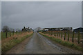
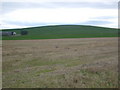
2
Alehouseburn Cottages
The relatively modern cottages stand just off the B9025, on the access road to Alehouseburn Farm. On the skyline is the Boyndie wind farm.
Image: © Anne Burgess
Taken: 1 Nov 2011
0.05 miles
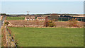
3
Alehouseburn Cottages
The relatively modern cottages stand just off the B9025, on the access road to Alehouseburn Farm, which can be seen to the right. It is in an adjacent square.
Image: © Anne Burgess
Taken: 1 Nov 2011
0.05 miles
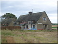
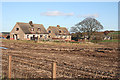
5
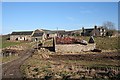
Alehouseburn
There are cattle in the byre and crops in the field, but apparently no people in the farm house.
Image: © Anne Burgess
Taken: 11 Feb 2008
0.16 miles