IMAGES TAKEN NEAR TO
Cornhill, BANFF, AB45 2AP
Introduction
This page details the photographs taken nearby to AB45 2AP by members of the Geograph project.
The Geograph project started in 2005 with the aim of publishing, organising and preserving representative images for every square kilometre of Great Britain, Ireland and the Isle of Man.

There are currently over 7.5m images from over14,400 individuals and you can help contribute to the project by visiting https://www.geograph.org.uk
Image Map
Images are licensed for reuse under creativecommons.org/licenses/by-sa/2.0
Notes
- Clicking on the map will re-center to the selected point.
- The higher the marker number, the further away the image location is from the centre of the postcode.
Image Listing (20 Images Found)
Images are licensed for reuse under creativecommons.org/licenses/by-sa/2.0
Image
Details
Distance
2
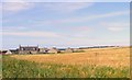
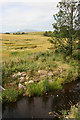
Drakemires
Drakemires Farm, near Cornhill.
Image: © Christopher Gillan
Taken: 14 Nov 2006
0.05 miles
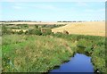
3
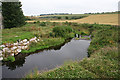
Burn of Boyne
A tranquil pool downstream from Milltown Bridge, evidently popular with anglers because access has been incorporated in the design of the new bridge, and there is a well-worn path to the water's edge.
Image: © Anne Burgess
Taken: 22 Jul 2014
0.06 miles
4
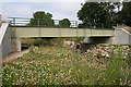
New Bridge at Milltown
This rather unlovely but admittedly robust-looking bridge is the replacement for Image It is provided with steps to access both sides, and paths underneath to the river banks.
Image: © Anne Burgess
Taken: 22 Jul 2014
0.06 miles
5
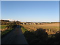
Beside the Burn of Boyne
Ripening barley beside the burn, with Knock Hill faint on the distant horizon.
Image: © Anne Burgess
Taken: 22 Jul 2014
0.06 miles
6
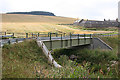
Milltown New Bridge
This is the replacement for Image Not as picturesque as its predecessor, but almost certainly more durable.
Image: © Anne Burgess
Taken: 22 Jul 2014
0.07 miles
8
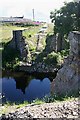
Damaged Bridge
This is the 'damage' referred to in Image Whoever prepared the sign is evidently a master of understatement; the bridge is not so much damaged as destroyed.
A press release from the roads authority, Aberdeenshire Council, was issued on 11 November 2009: "Diversions are to continue following the collapse of a rural bridge near Cornhill, Banff, earlier today (Tue, Nov 10). The bridge at Milton of Tillynaught, which spans the Burn of Boyne, was badly affected by the recent heavy flooding in the area and has been closed since Monday, November 2. Floodwaters at the time swelled some four metres above normal river level and significant damage to the bridge and its foundations became apparent as water levels fell. Aberdeenshire Council’s bridge experts planned to support the unstable bridge arch with a temporary girder, but the structure collapsed before work could begin. It is thought the category C-listed structure was originally built to provide access to a nearby water mill. More recently it has served as a local road link, and a small number of nearby households are directly affected by the closure. As a result, school bus arrangements are being altered and traffic to Cornhill will continue to be diverted via the B9022 and B9023 until further notice. Aberdeenshire Council will now examine options for the future of the bridge. A replacement is estimated to cost in the region of £1.3 million and could take up to a year to complete. The council will also look at the possibility of installing a temporary footbridge."
Nine months after its collapse, there is still no sign of work starting on a replacement.
Edit (2014): See Image] and Image
Image: © Anne Burgess
Taken: 5 Aug 2010
0.08 miles
9
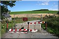
Road Closed
A 'Road closed' sign at the road junction proved an irresistible attraction, and on investigation, this is what I found. The sign reads, "Damaged Bridge. No access to vehicles or pedestrians". The word 'damaged' is a masterly piece of understatement. See Image
Image: © Anne Burgess
Taken: 5 Aug 2010
0.08 miles
10
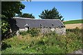
Old Mill at Milton of Tillynaught
I am assuming this is a mill from its windowless appearance and its site, right on the bank of the Burn of Boyne beside the farm of Milton of Tillynaught.
Image: © Anne Burgess
Taken: 5 Aug 2010
0.09 miles