IMAGES TAKEN NEAR TO
Moray Place, BANFF, AB45 1GR
Introduction
This page details the photographs taken nearby to Moray Place, AB45 1GR by members of the Geograph project.
The Geograph project started in 2005 with the aim of publishing, organising and preserving representative images for every square kilometre of Great Britain, Ireland and the Isle of Man.

There are currently over 7.5m images from over14,400 individuals and you can help contribute to the project by visiting https://www.geograph.org.uk
Image Map
Images are licensed for reuse under creativecommons.org/licenses/by-sa/2.0
Notes
- Clicking on the map will re-center to the selected point.
- The higher the marker number, the further away the image location is from the centre of the postcode.
Image Listing (5 Images Found)
Images are licensed for reuse under creativecommons.org/licenses/by-sa/2.0
Image
Details
Distance
2
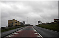
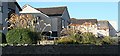
Layby on A98 at entrance to Banff from the west
Boyndie Road, with an hotel on the right.
Image: © Stanley Howe
Taken: 10 Sep 2012
0.20 miles
3
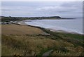
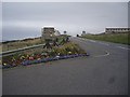
Path down to the shore from A98 near Banff
With distant views across Boyndie Bay to Whitehills (church on left horizon), and The Knock stretching out to sea on the right.
Image: © Stanley Howe
Taken: 10 Sep 2012
0.21 miles
4
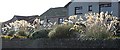
Pampas Grass
I hadn't noticed how much pampas grass there is in the new gardens by the A98 entering Banff, but they caught my eye this morning with the sun behind them.
Image: © Anne Burgess
Taken: 19 Sep 2007
0.22 miles
5
Pampas Grass
It's not nearly as eye-catching with the sun on it as it is against the light in Image]
Image: © Anne Burgess
Taken: 19 Sep 2007
0.22 miles