IMAGES TAKEN NEAR TO
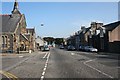
Seafield Street, BANFF, AB45 1EB
Introduction
This page details the photographs taken nearby to Seafield Street, AB45 1EB by members of the Geograph project.
The Geograph project started in 2005 with the aim of publishing, organising and preserving representative images for every square kilometre of Great Britain, Ireland and the Isle of Man.

There are currently over 7.5m images from over14,400 individuals and you can help contribute to the project by visiting https://www.geograph.org.uk
Image Map
Images are licensed for reuse under creativecommons.org/licenses/by-sa/2.0
Notes
- Clicking on the map will re-center to the selected point.
- The higher the marker number, the further away the image location is from the centre of the postcode.
Image Listing (94 Images Found)
Images are licensed for reuse under creativecommons.org/licenses/by-sa/2.0
Image
Details
Distance
1
Banff Bay is just visible through the trees.
Image: © Des Colhoun
Taken: 13 Sep 2006
0.05 miles
2
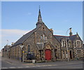
Banff Methodist church
Dating from 1877 and C-listed (LB22093): http://portal.historicenvironment.scot/designation/LB22093 .
Image: © Bill Harrison
Taken: 14 Apr 2018
0.09 miles
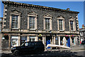
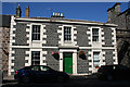
3
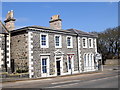
Seafield house, Banff
A striking B-listed (LB21942: http://portal.historicenvironment.scot/designation/LB21942 ) house (now offices) from 1853. Note the fine sash windows.
Image: © Bill Harrison
Taken: 14 Apr 2018
0.12 miles
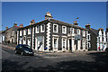
4

St Catherine's Street
The sunlit north side of the street is a row of fine plain traditional houses.
Image: © Anne Burgess
Taken: 25 Jul 2014
0.12 miles
5
Former Trinity Free Kirk Hall, Castle Street
This building is marked on the mid-Victorian six-inch Ordnance Survey map as a school, and as such must have been associated with the Trinity and Alvah Free Kirk next door. Both buildings are now run as Riverside Church by Harvest Ministries, a small independent Christian denomination. See http://www.harvestministries.org.uk/Groups/129403/Harvest_Ministries/Riverside_Banff/About_Us/About_Us.aspx
Image: © Anne Burgess
Taken: 25 Jul 2014
0.13 miles
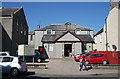
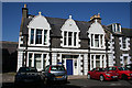
6
Former Lodge St Andrew's Masonic Hall
This is the Seafield Street frontage of Image], with a large Venetian window atfirst floor level.
Image: © Anne Burgess
Taken: 25 Jul 2014
0.13 miles
7
Seafield House, 37 Castle Street
One of many buildings in Banff designed by Thomas Mackenzie (1814-1854), this is now the office of the Registrar. It is in italianate style with a Doric portico.
Image: © Anne Burgess
Taken: 25 Jul 2014
0.13 miles
8
Winston House, 39 Castle Street
The central gable is inscribed '1897', but there seems to be some question of the house being of earlier date, and the rather overblown gables having been added later. The building is now office accommodation for Aberdeenshire Council.
Image: © Anne Burgess
Taken: 25 Jul 2014
0.14 miles
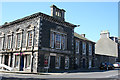
9
Banff Town Hall
This was formerly St Andrew's Lodge Masonic Hall, 31 - 35 Castle Street, and it is a Category A Listed Building. It was built in 1852-1853 and the architect was Thomas Mackenzie (1814-1854). The tall windows indicate the main floor, and the entrance is by the central door. See also Image
Image: © Anne Burgess
Taken: 25 Jul 2014
0.14 miles
10
The Gables, 29 Castle Street
This house dates from about 1849-1850 and is either designed by, or in the style of Thomas Mackenzie, depending which source you believe.
Image: © Anne Burgess
Taken: 25 Jul 2014
0.14 miles