IMAGES TAKEN NEAR TO
The Hythe, MACDUFF, AB44 1UQ
Introduction
This page details the photographs taken nearby to The Hythe, AB44 1UQ by members of the Geograph project.
The Geograph project started in 2005 with the aim of publishing, organising and preserving representative images for every square kilometre of Great Britain, Ireland and the Isle of Man.

There are currently over 7.5m images from over14,400 individuals and you can help contribute to the project by visiting https://www.geograph.org.uk
Image Map
Images are licensed for reuse under creativecommons.org/licenses/by-sa/2.0
Notes
- Clicking on the map will re-center to the selected point.
- The higher the marker number, the further away the image location is from the centre of the postcode.
Image Listing (126 Images Found)
Images are licensed for reuse under creativecommons.org/licenses/by-sa/2.0
Image
Details
Distance
1
Church Street
This is the street which climbs from Shore Street up to the kirk. The spire of the Macduff Arts Centre on the skyline.
Image: © Anne Burgess
Taken: 26 Jun 2008
0.04 miles
2
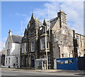
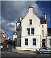
Macduff town hall, 17 Shore Street
The Scottish baronial town hall facing the harbour was designed by Aberdeen architects Pirie and Clyne in 1884 and is B-listed (LB37634): http://portal.historicenvironment.scot/designation/LB37634 . Next door is the former Clydesdale Bank and agent's house, also B-listed (LB37635): http://portal.historicenvironment.scot/designation/LB37635 .
Image: © Bill Harrison
Taken: 14 Apr 2018
0.05 miles
3
Macduff Town Hall
The Town Hall in Macduff
Image: © Graeme Smith
Taken: 29 Aug 2012
0.05 miles
4
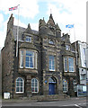
Town Hall
A rather forbidding building, on a steep slope so that when you go in the main door on Shore Street, you are faced with a vast staircase up to the actual hall on the first floor. A competition was held to design it in 1884, and the winning architects were the partnership Pirie and Clyne - John Bridgford Pirie and Arthur Clyne, with their apprentice Alexander Lorimer. The hall was openeind in 1885.
Image: © Anne Burgess
Taken: 8 Apr 2014
0.06 miles
5
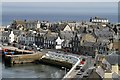
Shore Street
Shore Street runs along the harbour, at this point the outer harbour, equipped with seats from which the view to seaward can be enjoyed. The dark building near the left is the Town Hall, and the incongruous white block next to it is the intermittently eccentric Highland Haven Hotel. Macduff Parish Kirk dominates the west end of the town from its elevated position.
Image: © Anne Burgess
Taken: 26 Jun 2008
0.07 miles
6
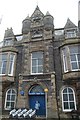
Institution Street
Looking up from the harbour. I think the crowstepped and turreted building must be a private house. The red triangle outside the council offices one block up the street probably contains a leading light to guide vessels safely into the harbour at night. These are normally in pairs, sited so that when one is seen directly above the other, the vessel is on the correct course, but in this case I could not see a second one.
Image: © Anne Burgess
Taken: 26 Jun 2008
0.07 miles
7
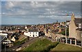
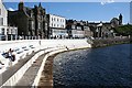
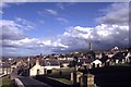
Macduff on the Moray Coast
This view of Shore Street and Crook O’ Ness Street was taken from the high vantage point of Church Street.
Image: © Walter Baxter
Taken: 21 May 2014
0.07 miles
8
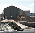
Boatyard
I speculate that the ribs are half of an old slipway which has been partly replaced by concrete, but I am happy to be corrected.
Image: © Anne Burgess
Taken: 8 Apr 2014
0.08 miles
9

Outer Harbour by Shore Street, Macduff
As seen from the junction of Church Street with Shand Street.
Image: © Stanley Howe
Taken: 23 Jul 2015
0.09 miles
10
Macduff - view from Church Street towards War Memorial
Image: © Colin Park
Taken: 19 Aug 1992
0.09 miles