IMAGES TAKEN NEAR TO
Station Brae, MACDUFF, AB44 1UL
Introduction
This page details the photographs taken nearby to Station Brae, AB44 1UL by members of the Geograph project.
The Geograph project started in 2005 with the aim of publishing, organising and preserving representative images for every square kilometre of Great Britain, Ireland and the Isle of Man.

There are currently over 7.5m images from over14,400 individuals and you can help contribute to the project by visiting https://www.geograph.org.uk
Image Map
Images are licensed for reuse under creativecommons.org/licenses/by-sa/2.0
Notes
- Clicking on the map will re-center to the selected point.
- The higher the marker number, the further away the image location is from the centre of the postcode.
Image Listing (37 Images Found)
Images are licensed for reuse under creativecommons.org/licenses/by-sa/2.0
Image
Details
Distance
1
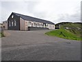
Macduff railway station (site), Aberdeenshire
Opened in 1872 by the Great North of Scotland Railway as the terminus of its line from Inveramsay, this station closed to passengers in 1951 and completely in 1961.
View south at the former forecourt. The building is now used as a retail establishment. The former engine shed can also be seen on the far right of the image.
Image: © Nigel Thompson
Taken: 5 Sep 2019
0.01 miles
2
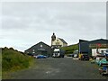
The site of Macduff Railway Station
'The Platform' is housed in the remaining building which comprised a good shed with passenger facilities alongside, built in 1872 when the line was extended to a new terminus.
The station closed to passengers in 1951 and freight in 1961, well before the Beeching era closures.
This view https://www.theplatform-macduff.co.uk/datafiles/uploaded/cms_gallery_photo/org/org_11_IMG_1157.JPG courtesy of the Platform website shows the station from a similar view direction.
Beyond is Macduff Parish Church, built in 1805 as a chapel of ease in Gamrie Parish, and extended in 1865. It is Listed Category B.
Image: © Alan Murray-Rust
Taken: 23 May 2022
0.04 miles
4
Banff Bay
The outskirts of Macduff seen across Banff Bay.
Image: © don cload
Taken: 25 May 2011
0.05 miles
5
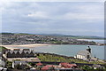
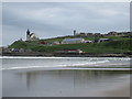
View from the top of Macduff War Memorial
Looking over Macduff Parish Church and across the bay towards Banff
Image: © Leslie Barrie
Taken: 19 Jun 2013
0.07 miles
6
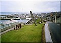
The fishing town of Macduff in Banffshire
Formerly known as Doune. Here you see the harbour and the promenade.
Image: © James Denham
Taken: Unknown
0.08 miles
7
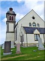
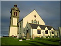
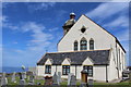
Macduff Parish Church
Viewed from within the graveyard area; from the west. The back of the tower bearing the clock is on the left.
Image: © Stanley Howe
Taken: 23 Jul 2015
0.08 miles
8
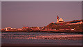
Banff Bay after Sunset
The extraordinary light on this view is actually the glow from clouds lit by the sun, which has already set. The street lights of Macduff are on, and the parish kirk stands almost like a beacon above a mass of gulls gathering on the sands.
Image: © Anne Burgess
Taken: 7 Nov 2011
0.08 miles
9
Macduff Parish Church
Built 1805 by James, 2nd Earl of Fife and remodelled by James Matthews, Aberdeen 1865.
Image: © Leslie Barrie
Taken: 19 Jun 2013
0.08 miles
10

Macduff Parish Church
The church is framed through a crane at Macduff Harbour.
Image: © Walter Baxter
Taken: 13 Jun 2014
0.08 miles