IMAGES TAKEN NEAR TO
Pine View, FRASERBURGH, AB43 9TZ
Introduction
This page details the photographs taken nearby to Pine View, AB43 9TZ by members of the Geograph project.
The Geograph project started in 2005 with the aim of publishing, organising and preserving representative images for every square kilometre of Great Britain, Ireland and the Isle of Man.

There are currently over 7.5m images from over14,400 individuals and you can help contribute to the project by visiting https://www.geograph.org.uk
Image Map
Images are licensed for reuse under creativecommons.org/licenses/by-sa/2.0
Notes
- Clicking on the map will re-center to the selected point.
- The higher the marker number, the further away the image location is from the centre of the postcode.
Image Listing (7 Images Found)
Images are licensed for reuse under creativecommons.org/licenses/by-sa/2.0
Image
Details
Distance
2
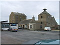
Watermill, Fraserburgh
the name gives it away, really. Disused Mill on the outskirts of town. To the left of the shot is the Watermill Bar + Millburn Lounge
Image: © Ken Fitlike
Taken: 19 Sep 2006
0.18 miles
4
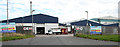
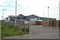
Young's Fish Processing Plant
Young's, headquartered in Grimsby, processes seafood and exports all over the world. This is one of its five plants in Scotland. See https://youngsseafood.co.uk/our-story/
Image: © Anne Burgess
Taken: 30 Aug 2016
0.19 miles
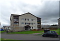
5
ASDA Supermarket
This is the rear of the new ASDA supermarket on Watermill Road.
Image: © Anne Burgess
Taken: 30 Aug 2016
0.19 miles
6
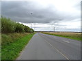
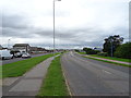
Boothby Road on the outskirts of Fraserburgh
Image: © JThomas
Taken: 22 Aug 2020
0.23 miles
7
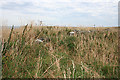
Waste Land
The map, and the crumbling remains of a dyke, suggest that this overgrown patch of ground was once a cultivated field.
Image: © Anne Burgess
Taken: 30 Aug 2016
0.25 miles