IMAGES TAKEN NEAR TO
Charlotte Street, FRASERBURGH, AB43 9JH
Introduction
This page details the photographs taken nearby to Charlotte Street, AB43 9JH by members of the Geograph project.
The Geograph project started in 2005 with the aim of publishing, organising and preserving representative images for every square kilometre of Great Britain, Ireland and the Isle of Man.

There are currently over 7.5m images from over14,400 individuals and you can help contribute to the project by visiting https://www.geograph.org.uk
Image Map
Images are licensed for reuse under creativecommons.org/licenses/by-sa/2.0
Notes
- Clicking on the map will re-center to the selected point.
- The higher the marker number, the further away the image location is from the centre of the postcode.
Image Listing (28 Images Found)
Images are licensed for reuse under creativecommons.org/licenses/by-sa/2.0
Image
Details
Distance
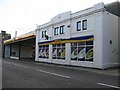
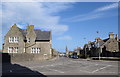
1
View along Charlotte Street, Fraserburgh
Fraserburgh has wide streets and an attractive 'spacious' and open feeling to it.
Image: © Bill Harrison
Taken: 6 May 2018
0.01 miles
2
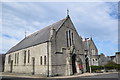
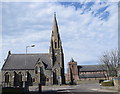
Our Lady Star of the Sea and St Drostan's RC church, Fraserburgh
The church dates from 1895 and lies on an approximate north-south orientation at the junction of Commerce Street and Lodge Walk. Just visible to the right is the presbytery. St Drostan (https://en.wikipedia.org/wiki/Drostan ) was a companion of St Columba and is thought to have been active in Aberdeenshire in the late 6th Century.
Image: © Bill Harrison
Taken: 6 May 2018
0.10 miles
3
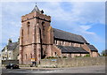
St Peter's Episcopal church, Fraserburgh
Built 1893 (tower added 1909) in brick-like red granite blocks and B-listed (LB31905): http://portal.historicenvironment.scot/designation/LB31905 . Note the dormer in the squat spire.
Image: © Bill Harrison
Taken: 6 May 2018
0.11 miles
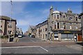
4
Looking down Victoria Street, Fraserburgh
In the left foreground, the B-listed (LB31904:
http://portal.historicenvironment.scot/designation/LB31904 ) rectory for the episcopal church and in the distance the spectacular spire of Fraserburgh south church (originally the free kirk).
Image: © Bill Harrison
Taken: 6 May 2018
0.13 miles
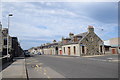
5
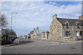
Junction of Albert and Victoria Streets, Fraserburgh
Image: © Bill Harrison
Taken: 6 May 2018
0.13 miles
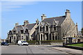
7
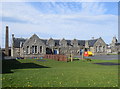
Former Fraserburgh infant school.
Now an annex for Aberdeenshire Council. Note the separate entrances for boys and girls in the 1901 building.
Image: © Bill Harrison
Taken: 6 May 2018
0.14 miles
8
Scottish kirk contrast
To the left, the west parish kirk on its prominent island site from 1876, which doesn't even merit C-listing, but it does have a Canmore record (173580): https://canmore.org.uk/site/173580/fraserburgh-the-hexagon-west-parish-church . The Buildings of Scotland (Pevsner) Guide calls it 'very impressive if austere'. In the right background is St Peter's episcopal church.
Image: © Bill Harrison
Taken: 6 May 2018
0.14 miles
9
Victorian villas, the Hexagon, Fraserburgh
Image: © Bill Harrison
Taken: 6 May 2018
0.15 miles