IMAGES TAKEN NEAR TO
Castle Street, FRASERBURGH, AB43 9DH
Introduction
This page details the photographs taken nearby to Castle Street, AB43 9DH by members of the Geograph project.
The Geograph project started in 2005 with the aim of publishing, organising and preserving representative images for every square kilometre of Great Britain, Ireland and the Isle of Man.

There are currently over 7.5m images from over14,400 individuals and you can help contribute to the project by visiting https://www.geograph.org.uk
Image Map
Images are licensed for reuse under creativecommons.org/licenses/by-sa/2.0
Notes
- Clicking on the map will re-center to the selected point.
- The higher the marker number, the further away the image location is from the centre of the postcode.
Image Listing (187 Images Found)
Images are licensed for reuse under creativecommons.org/licenses/by-sa/2.0
Image
Details
Distance
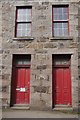
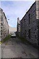
4
Council flats facing Quarry Road, Fraserburgh
Image: © Bill Harrison
Taken: 6 May 2018
0.04 miles
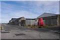
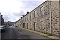
6
Fish sheds from Kinnaird Head Lighthouse
The sheds are by Fraserburgh harbour.
Image: © David Hawgood
Taken: 11 Sep 2007
0.07 miles
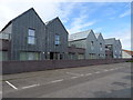
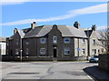
7
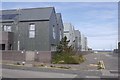
Metal clad houses, Quarry Road Fraserburgh
Image: © Richard Webb
Taken: 2 Aug 2020
0.07 miles
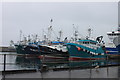
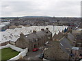
8
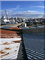
Balaclava Harbour, Fraserburgh, Aberdeenshire
Balaclava Harbour is the northernmost area of Fraserburgh Harbour. Work started on it in 1851 and it was named after the battle of 1854.
Image: © Claire Pegrum
Taken: 4 Oct 2021
0.08 miles