IMAGES TAKEN NEAR TO
East Street, FRASERBURGH, AB43 8ZX
Introduction
This page details the photographs taken nearby to East Street, AB43 8ZX by members of the Geograph project.
The Geograph project started in 2005 with the aim of publishing, organising and preserving representative images for every square kilometre of Great Britain, Ireland and the Isle of Man.

There are currently over 7.5m images from over14,400 individuals and you can help contribute to the project by visiting https://www.geograph.org.uk
Image Map
Images are licensed for reuse under creativecommons.org/licenses/by-sa/2.0
Notes
- Clicking on the map will re-center to the selected point.
- The higher the marker number, the further away the image location is from the centre of the postcode.
Image Listing (39 Images Found)
Images are licensed for reuse under creativecommons.org/licenses/by-sa/2.0
Image
Details
Distance
1
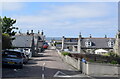
Mid Street, St Combs
The main streets run approximately north-sound with the gable ends of the former fishermen's cottages facing the road.
Image: © Bill Harrison
Taken: 5 Jun 2022
0.03 miles
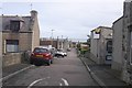
2
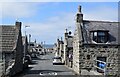
East Street, St Combs
St Combs was set out as a planned fishing village in the late 18th Century on an approximate grid pattern, with the main streets running north-south and gable ends facing the street. The fishing fleet is long gone and the village now houses commuters.
Image: © Bill Harrison
Taken: 5 Jun 2022
0.04 miles
3
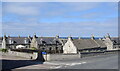
Cottages, St Combs
The former fishermen's cottages face south with their gable ends facing onto Mid Street.
Image: © Bill Harrison
Taken: 5 Jun 2022
0.05 miles
5
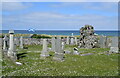
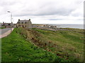
Remains of St Colomba's Church, St Combs
All that remains of the medieval church is some masonry from the west gable end now located in the modern graveyard, which is perhaps not surprising given that the church was abandoned in 1608. See Canmore record 21121 for more: https://canmore.org.uk/site/21121/st-combs-old-church .
Image: © Bill Harrison
Taken: 5 Jun 2022
0.06 miles
7
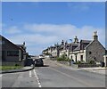
West Street, St Combs
Here, the terraced houses face the street, unlike the more unconventional arrangement on East Street: https://www.geograph.org.uk/photo/7245247 .
Image: © Bill Harrison
Taken: 5 Jun 2022
0.10 miles
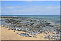
9
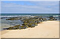
Coastal rocks at Kirk Lanes
These appear to be Cairnbulg diorite (https://en.wikipedia.org/wiki/Diorite ), being igneous bedrock formed approximately 444 to 485 million years ago in the Ordovician Period by intrusions of silica-poor magma.
Image: © Bill Harrison
Taken: 5 Jun 2022
0.11 miles
10
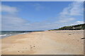
On the beach (St Combs)
Like many sandy beaches north of Aberdeen, it is deserted.
Image: © Bill Harrison
Taken: 5 Jun 2022
0.11 miles