IMAGES TAKEN NEAR TO
Cairness, FRASERBURGH, AB43 8XP
Introduction
This page details the photographs taken nearby to AB43 8XP by members of the Geograph project.
The Geograph project started in 2005 with the aim of publishing, organising and preserving representative images for every square kilometre of Great Britain, Ireland and the Isle of Man.

There are currently over 7.5m images from over14,400 individuals and you can help contribute to the project by visiting https://www.geograph.org.uk
Image Map
Images are licensed for reuse under creativecommons.org/licenses/by-sa/2.0
Notes
- Clicking on the map will re-center to the selected point.
- The higher the marker number, the further away the image location is from the centre of the postcode.
Image Listing (8 Images Found)
Images are licensed for reuse under creativecommons.org/licenses/by-sa/2.0
Image
Details
Distance
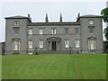
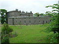
1
Cairness House
Cairness House was built in the 1790s, incorporating earlier buildings. It has a notable art collection and is open for tours. See http://www.cairnesshouse.com/
Image: © Anne Burgess
Taken: 1 May 2007
0.21 miles
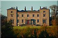
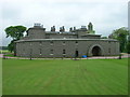
2
Cairness House
Much restored in recent years and now open to the public.
Image: © JThomas
Taken: 1 Jun 2008
0.22 miles
3
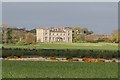
Cairness House, South Front
Cairness House viewed across its park. Where the trees are now, was supposed to be a lake. The house is photographed at sunset after a bright sunny day.
Image: © jamieperth
Taken: 12 Apr 2009
0.22 miles
5
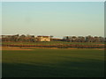
looking towards Cairness House
http://www.cairnesshouse.com/
Image: © Ken Fitlike
Taken: 3 Feb 2007
0.23 miles
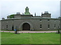
6
Cairness House Gardens
Much developed over the last few years.
Image: © JThomas
Taken: 1 Jun 2008
0.23 miles
8
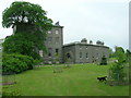
Cairness House
A side view. Nice cat as well.
Image: © JThomas
Taken: 1 Jun 2008
0.23 miles