IMAGES TAKEN NEAR TO
Crimond, FRASERBURGH, AB43 8RS
Introduction
This page details the photographs taken nearby to AB43 8RS by members of the Geograph project.
The Geograph project started in 2005 with the aim of publishing, organising and preserving representative images for every square kilometre of Great Britain, Ireland and the Isle of Man.

There are currently over 7.5m images from over14,400 individuals and you can help contribute to the project by visiting https://www.geograph.org.uk
Image Map
Images are licensed for reuse under creativecommons.org/licenses/by-sa/2.0
Notes
- Clicking on the map will re-center to the selected point.
- The higher the marker number, the further away the image location is from the centre of the postcode.
Image Listing (20 Images Found)
Images are licensed for reuse under creativecommons.org/licenses/by-sa/2.0
Image
Details
Distance
1
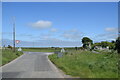
Aberdeenshire staggered junction
A minor road meets the B9033 in the flat Aberdeenshire landscape, with Newark Farm in the right background. The B9033 is about 12 km long and loops around from Lumms Crossroads on the A90 to a roundabout at Fraserburgh: https://www.sabre-roads.org.uk/wiki/index.php?title=B9033 .
Image: © Bill Harrison
Taken: 5 Jun 2022
0.11 miles
5
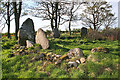
Berrybrae Recumbent Stone Circle (4)
All the surviving stones are in the west arc of the circle. The large dark one on the left is the recumbent, with the broken east flanker in front of it. The next one is still in its original position, but the one furthest to the right has been re-erected after falling over. See http://canmore.rcahms.gov.uk/en/site/21099/details/berrybrae/ for more information. Image]
Image: © Anne Burgess
Taken: 7 May 2015
0.17 miles
6
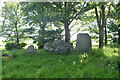
Berrybrae Recumbent Stone Circle (5)
The recumbent here has an unusual feature in the boss in the centre of its upper surface. Behind it, in the shade, is the tallest stone of the circle, the west flanker, and the broken east flanker is on the right. The stone at the far side of the circle had fallen but was re-erected in 1976. See http://canmore.rcahms.gov.uk/en/site/21099/details/berrybrae/ for more information. Image]
Image: © Anne Burgess
Taken: 7 May 2015
0.17 miles
7
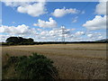
Berrybrae Recumbent Stone Circle (8)
The stone circle is inside this small circular wood in the field. Fortunately the crop was not so well grown that it precluded visiting the circle. Later in the year, it will be impossible because the crop will be too tall. See http://canmore.rcahms.gov.uk/en/site/21099/details/berrybrae/ for more information. Image]
Image: © Anne Burgess
Taken: 7 May 2015
0.18 miles
8

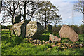
Berrybrae Recumbent Stone Circle (3)
The recumbent and flankers silhouetted against the afternoon sun. The west flanker (on the right) is as it originally was, but the east flanker has broken off, leaving only a short stump standing. See http://canmore.rcahms.gov.uk/en/site/21099/details/berrybrae/ for more information. Image]
Image: © Anne Burgess
Taken: 7 May 2015
0.18 miles
9
Berrybrae stone circle: recumbent stone and flankers
This site photographs better in the winter when the trees admit more light. For more, see Canmore listing 21099: https://canmore.org.uk/site/21099/berrybrae .
Image: © Bill Harrison
Taken: 5 Jun 2022
0.18 miles
10

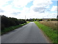
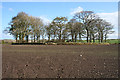
Berrybrae Recumbent Stone Circle location
The stone circle is located in this small wood.
Image: © Mary and Angus Hogg
Taken: 23 Aug 2019
0.18 miles