IMAGES TAKEN NEAR TO
New Pitsligo, FRASERBURGH, AB43 6PD
Introduction
This page details the photographs taken nearby to AB43 6PD by members of the Geograph project.
The Geograph project started in 2005 with the aim of publishing, organising and preserving representative images for every square kilometre of Great Britain, Ireland and the Isle of Man.

There are currently over 7.5m images from over14,400 individuals and you can help contribute to the project by visiting https://www.geograph.org.uk
Image Map
Images are licensed for reuse under creativecommons.org/licenses/by-sa/2.0
Notes
- Clicking on the map will re-center to the selected point.
- The higher the marker number, the further away the image location is from the centre of the postcode.
Image Listing (3 Images Found)
Images are licensed for reuse under creativecommons.org/licenses/by-sa/2.0
Image
Details
Distance
1
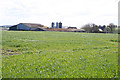
Brownhill
From this view, you'd think that 'Green Hollow' would be a more appropriate name than 'Brown Hill', with the buildings partly hidden in a dip.
Image: © Anne Burgess
Taken: 7 May 2015
0.04 miles
2
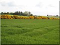
Gorse hedge near Brownhill
Gorse (or whin) is a very conspicuous feature of this area when in bloom in the spring.
Image: © Oliver Dixon
Taken: 21 May 2008
0.24 miles
3
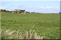
West Brownhill
West Brownhill is towards the left, and there is a glimpse of North Brownhill on the right.
Image: © Anne Burgess
Taken: 7 May 2015
0.24 miles