IMAGES TAKEN NEAR TO
New Pitsligo, FRASERBURGH, AB43 6PA
Introduction
This page details the photographs taken nearby to AB43 6PA by members of the Geograph project.
The Geograph project started in 2005 with the aim of publishing, organising and preserving representative images for every square kilometre of Great Britain, Ireland and the Isle of Man.

There are currently over 7.5m images from over14,400 individuals and you can help contribute to the project by visiting https://www.geograph.org.uk
Image Map
Images are licensed for reuse under creativecommons.org/licenses/by-sa/2.0
Notes
- Clicking on the map will re-center to the selected point.
- The higher the marker number, the further away the image location is from the centre of the postcode.
Image Listing (5 Images Found)
Images are licensed for reuse under creativecommons.org/licenses/by-sa/2.0
Image
Details
Distance
1
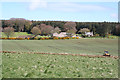
Leechesburn
Fields turning green south of New Pitsligo. The digger was working in a ditch at the field boundary.
Image: © Anne Burgess
Taken: 7 May 2015
0.02 miles

3
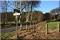
Bonnykelly junction south of New Pitsligo.
Image: © Des Colhoun
Taken: 14 Jan 2007
0.10 miles
4
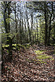
Woods near Sprottineuk
Sunshine filtered through the new leaves beside Image
Image: © Anne Burgess
Taken: 7 May 2015
0.19 miles
5
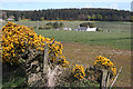
Name Unknown
The name of this farm is not on the maps, so if someone can tell me what it is called, I'll be very grateful.
Image: © Anne Burgess
Taken: 7 May 2015
0.25 miles