IMAGES TAKEN NEAR TO
Low Street, FRASERBURGH, AB43 6LL
Introduction
This page details the photographs taken nearby to Low Street, AB43 6LL by members of the Geograph project.
The Geograph project started in 2005 with the aim of publishing, organising and preserving representative images for every square kilometre of Great Britain, Ireland and the Isle of Man.

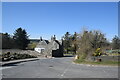
There are currently over 7.5m images from over14,400 individuals and you can help contribute to the project by visiting https://www.geograph.org.uk
Image Map
Images are licensed for reuse under creativecommons.org/licenses/by-sa/2.0
Notes
- Clicking on the map will re-center to the selected point.
- The higher the marker number, the further away the image location is from the centre of the postcode.
Image Listing (11 Images Found)
Images are licensed for reuse under creativecommons.org/licenses/by-sa/2.0
Image
Details
Distance
1
Rear view of the former Free Church manse, New Aberdour
It looks much more impressive from the front... https://www.geograph.org.uk/photo/4095786 . The free church was situated next to the Commercial Hotel on the High Street, but it is long since demolished.
Image: © Bill Harrison
Taken: 16 Apr 2021
0.03 miles
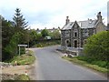
2
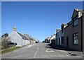
View up the High Street, New Aberdour
The street is some 600 metres long, with the parish kirk just visible at the other end.
Image: © Bill Harrison
Taken: 16 Apr 2021
0.03 miles
3
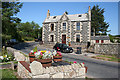
Old Manse
The type of stonework, with the small pieces between the larger stones, has a special name, which escapes me at the moment. However it's not all that common in this area.
Image] is the rear view of the house.
Image: © Anne Burgess
Taken: 25 Jul 2014
0.03 miles
4
High Street in New Aberdour
Looking north-eastward. A complementary view of High Street can be seen in : https://www.geograph.org.uk/photo/6328687
Image: © Peter Wood
Taken: 19 Nov 2019
0.05 miles
5
Southern approach to New Aberdour village
Approaching on the road from New Pitsligo.
Image: © Oliver Dixon
Taken: 21 May 2008
0.05 miles
6
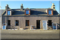
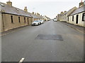
Renovations
A house in the main street of New Aberdour having new windows and doors installed.
Image: © Anne Burgess
Taken: 20 Jan 2017
0.09 miles
7
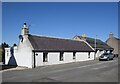
Former weavers' cottages, New Aberdour
Probably dating from ca. 1798, when the planned village was established. Note the lack of front doors. To the left is one of the many access points to the service lane at the back of the houses, which runs parallel to the main street.
Image: © Bill Harrison
Taken: 16 Apr 2021
0.16 miles
9
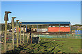
Welly Boots
This building isn't on the maps. This looks like a good way to make use of worn-out green welly boots!
Image: © Anne Burgess
Taken: 20 Jan 2017
0.21 miles
10
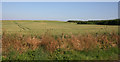
Field of Barley
One of many such in this part of the world. Interestingly, the crop doesn't seem to be nearly as ripe here as they are further inland.
Image: © Anne Burgess
Taken: 25 Jul 2014
0.22 miles