IMAGES TAKEN NEAR TO
Mintlaw, PETERHEAD, AB42 5JR
Introduction
This page details the photographs taken nearby to AB42 5JR by members of the Geograph project.
The Geograph project started in 2005 with the aim of publishing, organising and preserving representative images for every square kilometre of Great Britain, Ireland and the Isle of Man.

There are currently over 7.5m images from over14,400 individuals and you can help contribute to the project by visiting https://www.geograph.org.uk
Image Map
Images are licensed for reuse under creativecommons.org/licenses/by-sa/2.0
Notes
- Clicking on the map will re-center to the selected point.
- The higher the marker number, the further away the image location is from the centre of the postcode.
Image Listing (5 Images Found)
Images are licensed for reuse under creativecommons.org/licenses/by-sa/2.0
Image
Details
Distance
1
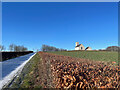
Pitfour Chapel
A snowy approach toward Pitfour Chapel and the estate
Image: © Ralph Greig
Taken: 19 Feb 2022
0.19 miles
2
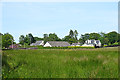
Taits Wells
There has been quite a lot of new building around the farm of Tait's Wells in recent decades.
Image: © Anne Burgess
Taken: 25 Jun 2018
0.20 miles
3
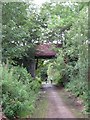
Formartine and Buchan Way - Bridge near Mintlaw Station
A well maintained section of this cycleway.
Image: © Mike and Kirsty Grundy
Taken: 26 Jul 2007
0.22 miles
4
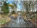
Cross road of tracks
At this location you have the option of:-
Straight ahead to Mintlaw
Left towards Fetterangus
Right towards Aden Park
And behind towards Pitfour Lake
Image: © Ralph Greig
Taken: 13 Jan 2022
0.23 miles
5
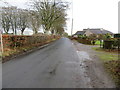
Road at Dunshillock approaching Balring Farm
Looking north-eastward.
Image: © Peter Wood
Taken: 22 Nov 2019
0.25 miles