IMAGES TAKEN NEAR TO
Stuartfield, PETERHEAD, AB42 5DT
Introduction
This page details the photographs taken nearby to AB42 5DT by members of the Geograph project.
The Geograph project started in 2005 with the aim of publishing, organising and preserving representative images for every square kilometre of Great Britain, Ireland and the Isle of Man.

There are currently over 7.5m images from over14,400 individuals and you can help contribute to the project by visiting https://www.geograph.org.uk
Image Map
Images are licensed for reuse under creativecommons.org/licenses/by-sa/2.0
Notes
- Clicking on the map will re-center to the selected point.
- The higher the marker number, the further away the image location is from the centre of the postcode.
Image Listing (2 Images Found)
Images are licensed for reuse under creativecommons.org/licenses/by-sa/2.0
Image
Details
Distance
1
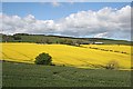
Dens of Crichie
Dens stands above fields of rape, on the slopes of the Hill of Dens.
Image: © Anne Burgess
Taken: 11 May 2009
0.21 miles
2
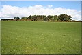
Hill of Dens
The woodland beyond the rather dull field is one end of a belt of plantings which snakes round the summit of the hill.
Image: © Anne Burgess
Taken: 11 May 2009
0.21 miles