IMAGES TAKEN NEAR TO
The Square, PETERHEAD, AB42 4EN
Introduction
This page details the photographs taken nearby to The Square, AB42 4EN by members of the Geograph project.
The Geograph project started in 2005 with the aim of publishing, organising and preserving representative images for every square kilometre of Great Britain, Ireland and the Isle of Man.

There are currently over 7.5m images from over14,400 individuals and you can help contribute to the project by visiting https://www.geograph.org.uk
Image Map
Images are licensed for reuse under creativecommons.org/licenses/by-sa/2.0
Notes
- Clicking on the map will re-center to the selected point.
- The higher the marker number, the further away the image location is from the centre of the postcode.
Image Listing (12 Images Found)
Images are licensed for reuse under creativecommons.org/licenses/by-sa/2.0
Image
Details
Distance
1
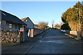
Duke Street
Duke Street, also sometimes called South Street, is one of two roads at right angles to the main street of Fetterangus. The name of the street has nothing to do with any noble gentleman; it is the Scots word 'deuk', meaning a duck, and refers to the duck pond which was once at the lower end of the street.
Image: © Anne Burgess
Taken: 6 Jan 2015
0.02 miles
2
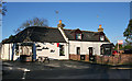
The Fishie Pub
Although the formal name of the village is Fetterangus, it is referred to locally as Fishie, hence the name of the village pub. Sadly, it was not open until 3 pm today, so I was unable to sample its wares (not that I would have been tempted by the alcoholic wares, of course, as I was driving).
Image: © Anne Burgess
Taken: 6 Jan 2015
0.02 miles
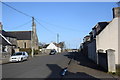
3
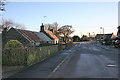
North Place
North place would be the continuation of Duke Street if it were not for the latter curving round to leave a grassy area on the south side of the Square. In that square, at the foot of this street, is the site of the United Presbyterian kirk which was opened in 1882. In 1929 the United Presbyterian Church was reunited with the Church of Scotland. The UP kirk was abandoned, and was demolished in the 1930s, and North Place extended over its site to meet the main street. If you enlarge the map, you can easily see the shape of the original diagonally-placed square.
Image: © Anne Burgess
Taken: 6 Jan 2015
0.04 miles
5
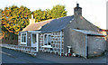
Old Cottage
This is one of the older cottages still standing in Fetterangus, with the date 1795 picked out in white paint at the top of the wall. It is in Duke Street.
Image: © Anne Burgess
Taken: 6 Jan 2015
0.05 miles
6
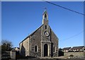
Fetterangus parish kirk
According to the Buildings of Scotland (Pevsner) Guide, the kirk was built in 1880 but there is no Canmore listing; compare: http://www.scottishchurches.org.uk/sites/site/id/10092/name/Fetterangus+Parish+Church%2C+Old+Deer+Old+Deer+Grampian .
Image: © Bill Harrison
Taken: 22 Feb 2020
0.07 miles
7
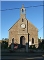
Fetterangus Parish Kirk
Fetterangus belongs to the parish of Old Deer, and did not get its own kirk until the 19th century, to provide services for the growing population of the village. It isn't marked on the first edition of the Ordnance Survey six-inch map, which was surveyed in 1869-70, but it is on all the later maps. That, and the style of building, both indicate that it was built in the latter part of the 19th century, but the exact date of construction appears to be unknown.
Image: © Anne Burgess
Taken: 6 Jan 2015
0.07 miles
8
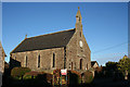
Fetterangus Parish Kirk
Fetterangus belongs to the parish of Old Deer, and did not get its own kirk until the 19th century, to provide services for the growing population of the village. It isn't marked on the first edition of the Ordnance Survey six-inch map, which was surveyed in 1869-70, but it is on all the later maps. That, and the style of building, both indicate that it was built in the latter part of the 19th century, but the exact date of construction appears to be unknown.
Image: © Anne Burgess
Taken: 6 Jan 2015
0.07 miles
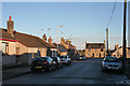
9
Ferguson Street, Fetterangus
The main street through the improvement village founded in 1752 by James Ferguson of Pitfour: https://en.wikipedia.org/wiki/James_Ferguson,_Lord_Pitfour .
Image: © Bill Harrison
Taken: 22 Feb 2020
0.07 miles
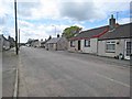
10
Gaval Street
The eastern half of the main street in Fetterangus is Gaval Street, the name being that of a farm outside the village. The house at the end of the street is the village's former post office, and at the time of writing it is for sale. Most of the older cottages have been either altered beyond recognition, or replaced by new ones.
Image: © Anne Burgess
Taken: 6 Jan 2015
0.14 miles