IMAGES TAKEN NEAR TO
Playing Fields, PETERHEAD, AB42 4AL
Introduction
This page details the photographs taken nearby to Playing Fields, AB42 4AL by members of the Geograph project.
The Geograph project started in 2005 with the aim of publishing, organising and preserving representative images for every square kilometre of Great Britain, Ireland and the Isle of Man.

There are currently over 7.5m images from over14,400 individuals and you can help contribute to the project by visiting https://www.geograph.org.uk
Image Map
Images are licensed for reuse under creativecommons.org/licenses/by-sa/2.0
Notes
- Clicking on the map will re-center to the selected point.
- The higher the marker number, the further away the image location is from the centre of the postcode.
Image Listing (10 Images Found)
Images are licensed for reuse under creativecommons.org/licenses/by-sa/2.0
Image
Details
Distance
1
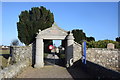
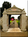
War memorial gateway, Fetterangus old kirkyard
The pink granite inscription reads: In proud and grateful memory / of the men of Fetterangus / who gave their lives for freedom / in the Great War. The names of the fallen are on tablets either side of the gates.
Image: © Bill Harrison
Taken: 22 Feb 2020
0.08 miles
2
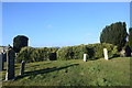
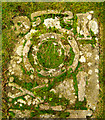
Fetterangus Kirkyard
There is little left of the kirk which once stood in this burial ground - just a rickle of stanes behind these gravestones.
Image: © Anne Burgess
Taken: 7 May 2009
0.09 miles
3
Remains of Fetterangus old kirk
The church dedicated to St Fergus is said to have been built ca. 1120 and is thus 900 years old in 2020. There is not much left beyond footings, which are completely covered in ivy. See Canmore record 20737: https://canmore.org.uk/site/20737/fetterangus-church .
Image: © Bill Harrison
Taken: 22 Feb 2020
0.09 miles
4
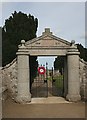
Fetterangus Kirkyard Gate
This granite gateway serves as the parish's war memorial. I note that though a new sign saying 'Please Keep Gates Closed' has been attached to the gate since Martyn Gorman took Image] in 2007, the gate still stood open in 2009.
Image: © Anne Burgess
Taken: 7 May 2009
0.09 miles
5
First World War memorial in the form of a gate into Fetterangus kirkyard
The old kirk, reputedly built circa 1120 and dedicated to St. Fergus, was granted to the monks of St. Thomas of Arbroath by Ralph Le Neym about the year 1200.
Image: © Martyn Gorman
Taken: 15 Feb 2007
0.12 miles
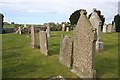
6
Old 18th century tombstone, Fetterangus kirkyard.
The old kirk of Fetterangus, reputedly built circa 1120 and dedicated to St. Fergus, was granted to the monks of St. Thomas of Arbroath by Ralph Le Neym about the year 1200. Only the remnants of the four walls remain in the form of loose rubble stones on a slight mound in the kirkyard.
There are approximately 37 recumbent 18th century tombstones in the yard, 2 of which are particularly well-decorated with old grave symbols including crossed femurs, skulls, coffins and hour-glasses.
Image: © Martyn Gorman
Taken: 15 Feb 2007
0.12 miles
7
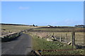
Looking down the road...
with Braeside of Fetterangus and Braeside of Gaval crofts visible in the distance.
Image: © Bill Harrison
Taken: 22 Feb 2020
0.16 miles
8
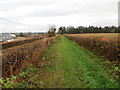
Hedge-lined footpath between road and field near to Fetterangus
Looking north-eastward. A footpath sign indicated that it is 3 miles to Mintlaw.
Image: © Peter Wood
Taken: 22 Nov 2019
0.16 miles
9
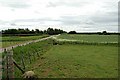
By Fetterangus
Farmland and a road junction near Fetterangus Churchyard.
Image: © Jim Bain
Taken: 18 Jun 2006
0.20 miles
10
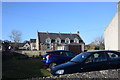
Fetterangus primary school
On an odd site set back from the road behind private gardens. School roll (2020): 41.
Image: © Bill Harrison
Taken: 22 Feb 2020
0.21 miles