IMAGES TAKEN NEAR TO
Jan Mayen Drive, PETERHEAD, AB42 3PX
Introduction
This page details the photographs taken nearby to Jan Mayen Drive, AB42 3PX by members of the Geograph project.
The Geograph project started in 2005 with the aim of publishing, organising and preserving representative images for every square kilometre of Great Britain, Ireland and the Isle of Man.

There are currently over 7.5m images from over14,400 individuals and you can help contribute to the project by visiting https://www.geograph.org.uk
Image Map
Images are licensed for reuse under creativecommons.org/licenses/by-sa/2.0
Notes
- Clicking on the map will re-center to the selected point.
- The higher the marker number, the further away the image location is from the centre of the postcode.
Image Listing (10 Images Found)
Images are licensed for reuse under creativecommons.org/licenses/by-sa/2.0
Image
Details
Distance
1
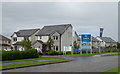
Sovereign Gate
New housing estate on the western edge of Peterhead.
Image: © JThomas
Taken: 22 Aug 2020
0.06 miles
2
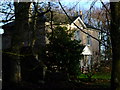
Howe o' Buchan House, Peterhead
This imposing Category C(s) Listed Building stands beside the roundabout at the Howe o' Buchan on the outskirts of Peterhead. From an inscription above a door Image, it would appear that this house may date from at least 1711, although RCAHMS's CANMORE website http://canmore.rcahms.gov.uk/en/site/21251/details/howe+o+buchan/ has it dating from the 1800's. Research would tend to indicate that the land at Howe O' Buchan was purchased by one Thomas Walker, whose family were originally occupied Waulkmill, a small wool mill and croft on the Aberdour shore that had been owned by the family since about 1720. So unless the house was already there when the land was purchased, the date of 1711 would appear incorrect as a date of building.
Image: © Iain Smith
Taken: 9 Dec 2009
0.08 miles
3
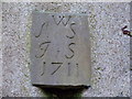
Inscription above Howe O' Buchan House
Confusingly, this date of 1711 seems to be unrelated to the age of the house.
Image: © Iain Smith
Taken: 9 Dec 2009
0.08 miles
4
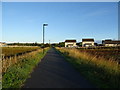
Formartine and Buchan Way, Coplandhill
Heading out of Peterhead.
Image: © JThomas
Taken: 24 Aug 2020
0.10 miles
5
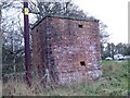
Unidentified Brick Structure at the Howe o' Buchan
This brick built structure at the western roundabout entry into Peterhead has been incorrectly classified as a two storey pillbox in the Defence of Britain database. Closer examination shows that the "embrasures" are in actual fact for ventilation. So whilst it is as yet unclear what the building was for, it most certainly was never a pillbox.
As ever, if anyone has an idea about this one, I'd be keen to hear from you.
Image: © Iain Smith
Taken: 7 Dec 2009
0.11 miles
6
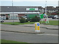
ASDA supermarket, Peterhead
The Ordnance Survey map gridline neatly bisects the building. NK109 to the left (frozen goods and beer etc) NK110 to the right (veg, meat, groceries etc)
Image: © Ken Fitlike
Taken: 2 Sep 2006
0.12 miles
7

Railway Crossing near Peterhead
This junction of the old Formartine & Buchan railway line ( http://en.wikipedia.org/wiki/Formartine_and_Buchan_Way ) between Peterhead and Inverugie still retains the original pedestrian gates.
Image: © Iain Smith
Taken: 9 Dec 2009
0.17 miles
9
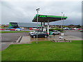
Supermarket service station, Coplandhill, Peterhead
Image: © JThomas
Taken: 22 Aug 2020
0.19 miles
10
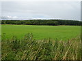
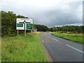
Grassland and woodland near Peterhead
Off the A950.
Image: © JThomas
Taken: 22 Aug 2020
0.25 miles