IMAGES TAKEN NEAR TO
Inverugie, PETERHEAD, AB42 3DQ
Introduction
This page details the photographs taken nearby to AB42 3DQ by members of the Geograph project.
The Geograph project started in 2005 with the aim of publishing, organising and preserving representative images for every square kilometre of Great Britain, Ireland and the Isle of Man.

There are currently over 7.5m images from over14,400 individuals and you can help contribute to the project by visiting https://www.geograph.org.uk
Image Map
Images are licensed for reuse under creativecommons.org/licenses/by-sa/2.0
Notes
- Clicking on the map will re-center to the selected point.
- The higher the marker number, the further away the image location is from the centre of the postcode.
Image Listing (7 Images Found)
Images are licensed for reuse under creativecommons.org/licenses/by-sa/2.0
Image
Details
Distance
1
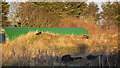
Air Raid Shelter - RAF Peterhead
I was surprised to discover that the WW2 airfield complex between Longside and Peterhead was more extensive than I first thought. Situated some distance to the east of the airfield itself are the footings of several huts, presumably similar to the extant example in the background.
The main subject of this image however, is the Stanton Air Raid Shelter, one of 4 extant at this site.
Image: © Iain Smith
Taken: 11 Jan 2011
0.07 miles
2
Paths at Berryhill
A new set of paths around Berryhill
Image: © Ralph Greig
Taken: 31 Jan 2023
0.09 miles
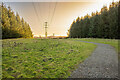
3
Formartine and Buchan Way
Heading out of Peterhed on the former Formartine and Buchan Railway.
Image: © JThomas
Taken: 24 Aug 2020
0.21 miles
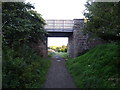
5
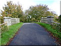
Railway Bridge near Inverugie Station
Railway bridge carrying a minor road over the former Formartine and Buchan Way line.
Image: © Iain Smith
Taken: 7 Oct 2010
0.23 miles
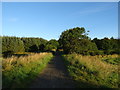
6
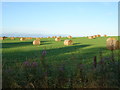
Field with bales beside the Formartine and Buchan Way
Image: © JThomas
Taken: 24 Aug 2020
0.24 miles
7
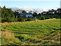
Grassland beside the Formartine and Buchan Way
Image: © JThomas
Taken: 24 Aug 2020
0.24 miles