IMAGES TAKEN NEAR TO
Orchard Grove, PETERHEAD, AB42 2WD
Introduction
This page details the photographs taken nearby to Orchard Grove, AB42 2WD by members of the Geograph project.
The Geograph project started in 2005 with the aim of publishing, organising and preserving representative images for every square kilometre of Great Britain, Ireland and the Isle of Man.

There are currently over 7.5m images from over14,400 individuals and you can help contribute to the project by visiting https://www.geograph.org.uk
Image Map
Images are licensed for reuse under creativecommons.org/licenses/by-sa/2.0
Notes
- Clicking on the map will re-center to the selected point.
- The higher the marker number, the further away the image location is from the centre of the postcode.
Image Listing (6 Images Found)
Images are licensed for reuse under creativecommons.org/licenses/by-sa/2.0
Image
Details
Distance
3
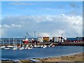
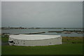
Peterhead Bay
In the background the breakwater built by convict labour. In the middle distance silos of drilling mud for the offshore oil industry and yachts berthed in the Peterhead marina. In the foreground the roofs of holiday caravans and the "Lido" sands.
Image: © Martyn Gorman
Taken: Unknown
0.23 miles
4
The road to the industrial estate
Takes you up towards Dales industrial estate. As long as you're not a lorry
Image: © Ralph Greig
Taken: 8 Mar 2023
0.23 miles
5
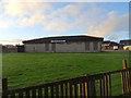
The Heritage Centre overlooking Peterhead Bay
Image: © Des Colhoun
Taken: 6 Dec 2009
0.24 miles
6
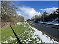
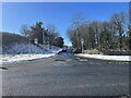
Heading into Peterhead
Looking towards Peterhead on the main road from Aberdeen
Image: © Ralph Greig
Taken: 8 Mar 2023
0.24 miles