IMAGES TAKEN NEAR TO
West Road, PETERHEAD, AB42 2AL
Introduction
This page details the photographs taken nearby to West Road, AB42 2AL by members of the Geograph project.
The Geograph project started in 2005 with the aim of publishing, organising and preserving representative images for every square kilometre of Great Britain, Ireland and the Isle of Man.

There are currently over 7.5m images from over14,400 individuals and you can help contribute to the project by visiting https://www.geograph.org.uk
Image Map
Images are licensed for reuse under creativecommons.org/licenses/by-sa/2.0
Notes
- Clicking on the map will re-center to the selected point.
- The higher the marker number, the further away the image location is from the centre of the postcode.
Image Listing (8 Images Found)
Images are licensed for reuse under creativecommons.org/licenses/by-sa/2.0
Image
Details
Distance
4
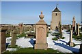
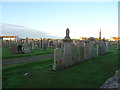
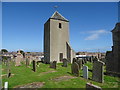
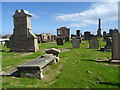
St Peter's kirkyard, Peterhead
The gravestone in the middle foreground is the family grave of the Grays, a dynasty of whaling captains who travelled to Greenland waters in the 19th century.
The tower in the background is part of the old church of St Peter. It was used in the early 1800s as a look out by men guarding the cemetery against grave robbers in search of fresh corpses for the Aberdeen anatomy schools.
Image: © Martyn Gorman
Taken: 4 Nov 2006
0.24 miles
5
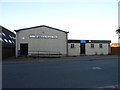
Middleton Scout Hut, Peterhead
On York Street.
Image: © JThomas
Taken: 24 Aug 2020
0.24 miles
6
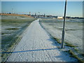
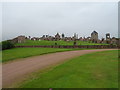
Peterhead, path over the links
....joining the new Clerkhill 'suburbia' with the 'auld toon'
Image: © Ken Fitlike
Taken: 20 Jan 2004
0.24 miles
7
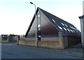
Kingdom Hall of Jehovah's Witnesses, Peterhead
On York Street.
Image: © JThomas
Taken: 24 Aug 2020
0.25 miles