IMAGES TAKEN NEAR TO
Ugie Road, PETERHEAD, AB42 1LZ
Introduction
This page details the photographs taken nearby to Ugie Road, AB42 1LZ by members of the Geograph project.
The Geograph project started in 2005 with the aim of publishing, organising and preserving representative images for every square kilometre of Great Britain, Ireland and the Isle of Man.

There are currently over 7.5m images from over14,400 individuals and you can help contribute to the project by visiting https://www.geograph.org.uk
Image Map
Images are licensed for reuse under creativecommons.org/licenses/by-sa/2.0
Notes
- Clicking on the map will re-center to the selected point.
- The higher the marker number, the further away the image location is from the centre of the postcode.
Image Listing (17 Images Found)
Images are licensed for reuse under creativecommons.org/licenses/by-sa/2.0
Image
Details
Distance
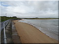
2
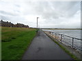
Buchanhaven, Peterhead
The Buchanhaven area of the town, viewed from "Ower the Water" which is the golf course side of the River Ugie reached by the Birnie Memorial Bridge as previously submitted in this grid square by Ken Fitlike.
Image: © Jim Davidson
Taken: 6 Feb 2003
0.10 miles
5
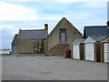
Salmon Smoke House
The oldest building in Peterhead, dating back to 1585. Still working, and operated by Ugie Salmon Fishings, this is probably the oldest working premises in Scotland.
Image: © Iain Smith
Taken: 23 Jul 2009
0.14 miles
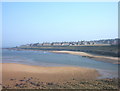
10
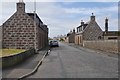
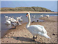
Buchanhaven shore
The old fishing village now just part of Peterhead
Image: © Ralph Greig
Taken: 8 Mar 2023
0.22 miles