IMAGES TAKEN NEAR TO
Ward Street, PETERHEAD, AB42 0HH
Introduction
This page details the photographs taken nearby to Ward Street, AB42 0HH by members of the Geograph project.
The Geograph project started in 2005 with the aim of publishing, organising and preserving representative images for every square kilometre of Great Britain, Ireland and the Isle of Man.

There are currently over 7.5m images from over14,400 individuals and you can help contribute to the project by visiting https://www.geograph.org.uk
Image Map
Images are licensed for reuse under creativecommons.org/licenses/by-sa/2.0
Notes
- Clicking on the map will re-center to the selected point.
- The higher the marker number, the further away the image location is from the centre of the postcode.
Image Listing (90 Images Found)
Images are licensed for reuse under creativecommons.org/licenses/by-sa/2.0
Image
Details
Distance
2
Cottages, Port Erroll
The cottages are separated from their front gardens by the road to the harbour.
Image: © Bill Harrison
Taken: 25 Mar 2012
0.03 miles
3
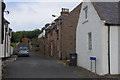
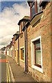
Hill Street, Port Erroll
Houses from the time when Port Erroll was a small fishing village.
Image: © Mike Pennington
Taken: 2 Aug 2012
0.04 miles
4
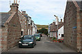
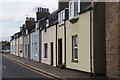
Green Street
Neat cottages, solidly built of local granite, in a side street in Port Erroll.
Image: © Anne Burgess
Taken: 5 Aug 2011
0.04 miles
5
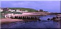
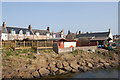
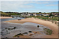
Port Erroll
Port Erroll lies on the banks of the Water of Cruden. In the foreground are the remains of wartime anti-tank defences.
Image: © Anne Burgess
Taken: Unknown
0.04 miles
6
Fishermen's houses Port Errol
Old terraced houses in the fishing village of Port Errol, Cruden Bay.
Image: © Martyn Gorman
Taken: 28 May 2006
0.04 miles
7

Terraced houses, main Street, Port Errol, Cruden Bay
Old houses in the fishing village of Port Errol.
Image: © Martyn Gorman
Taken: 28 May 2006
0.04 miles
8
Harbour Street, Port Erroll
Traditional fisher houses.
Image: © Mike Pennington
Taken: 2 Aug 2012
0.04 miles
9
Tank traps, Port Errol
See Canmore record 81336 for more: https://canmore.org.uk/site/81336/port-erroll .
Image: © Bill Harrison
Taken: 15 Apr 2018
0.05 miles
10
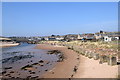
Port Erroll
The Ladies' Bridge over the Cruden Water is in the next square, but the foreground is in this square. I wonder how much was spent on the thousands upon thousands of concrete anti-tank blocks erected along the coast during the Second World War?
Image: © Anne Burgess
Taken: 5 Aug 2011
0.05 miles