IMAGES TAKEN NEAR TO
AB4 1QH
Introduction
This page details the photographs taken nearby to AB4 1QH by members of the Geograph project.
The Geograph project started in 2005 with the aim of publishing, organising and preserving representative images for every square kilometre of Great Britain, Ireland and the Isle of Man.

There are currently over 7.5m images from over14,400 individuals and you can help contribute to the project by visiting https://www.geograph.org.uk
Image Map
Images are licensed for reuse under creativecommons.org/licenses/by-sa/2.0
Notes
- Clicking on the map will re-center to the selected point.
- The higher the marker number, the further away the image location is from the centre of the postcode.
Image Listing (4 Images Found)
Images are licensed for reuse under creativecommons.org/licenses/by-sa/2.0
Image
Details
Distance
1
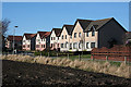
Corskie Drive
Corskie Drive is on the other side of the houses, which, for the time being, enjoy a fine open view across fields to the south. I would be astonished, however, if further building does not take place in the fields between here and the cemetery.
Image: © Anne Burgess
Taken: 26 Feb 2013
0.17 miles
4
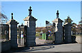
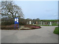
Myrus Cemetery Gates
The gates to the large, relatively modern, cemetery serving Macduff and environs.
Image: © Anne Burgess
Taken: 26 Feb 2013
0.25 miles