IMAGES TAKEN NEAR TO
Plover Place, ELLON, AB41 9DW
Introduction
This page details the photographs taken nearby to Plover Place, AB41 9DW by members of the Geograph project.
The Geograph project started in 2005 with the aim of publishing, organising and preserving representative images for every square kilometre of Great Britain, Ireland and the Isle of Man.

There are currently over 7.5m images from over14,400 individuals and you can help contribute to the project by visiting https://www.geograph.org.uk
Image Map
Images are licensed for reuse under creativecommons.org/licenses/by-sa/2.0
Notes
- Clicking on the map will re-center to the selected point.
- The higher the marker number, the further away the image location is from the centre of the postcode.
Image Listing (21 Images Found)
Images are licensed for reuse under creativecommons.org/licenses/by-sa/2.0
Image
Details
Distance
1
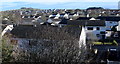
Ellon suburban
Ellon has expanded greatly in the last 20 years and now has its own suburban sprawl.
Image: © Bill Harrison
Taken: 1 Mar 2020
0.02 miles
2
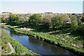
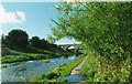
River Ythan
On the south (right) bank of the river is a large area of housing, none of which is on the 1976 1:50,000 map. This indicates how fast Ellon has grown in recent decades.
Image: © Anne Burgess
Taken: 11 May 2009
0.09 miles
3
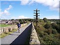
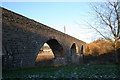
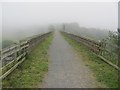
Ellon Viaduct, Aberdeenshire
The viaduct at Ellon carried the Great North of Scotland Railway from Aberdeen to the fishing towns of Peterhead and Fraserburgh over the River Ythan. Passenger trains ceased to run in 1965 with closure to all traffic in 1979. Ellon was also the junction for a branch built to serve the railway companies massive luxury hotel at Cruden Bay. The whole of the 38 miles between Dyce and Peterhead and the 16 miles between Maud Junction and Fraserburgh have been converted into a long distance cycle/walkway, the 'Formartine & Buchan Way'
Image: © Ralph Rawlinson
Taken: 18 Sep 2004
0.10 miles
4
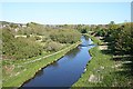
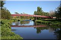
River Ythan
Looking downstream from the former railway viaduct, which now carries the Formartine and Buchan Way, a long-distance walking and cycling route on the bed of the former railway.
Image: © Anne Burgess
Taken: 11 May 2009
0.11 miles
5
Old Rail Bridge
The old rail bridge over the Ythan , once carrying the passenger and goods trains of the Buchan Line now it carries a walkway the telegraph line though is still sadly redundant.
Image: © Andrew Wood
Taken: 9 Jan 2011
0.11 miles
6
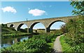
Old Railway Bridge
As part of the infamous Beeching cuts the death knell of the Buchan Line, Ellon Station and the bridge went into disuse. Unlike its partner over the Pitmeden road to the south this bridge survived and now provides walkers and cyclists with a safe, dry and elevated crossing of the Ythan.
Image: © Andrew Wood
Taken: 9 Aug 2001
0.11 miles
7
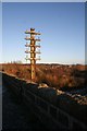
No more lines
The telegraph as well as the rail lines have long gone on the old rail bridge over the Ythan at Ellon.
Image: © Andrew Wood
Taken: 9 Jan 2011
0.12 miles
8
Ellon Railway Bridge
From the Ythan walkway the old railway bridge spans the Ythan. Now itself a walkway part of the Formartine Line Walk which runs from Dyce north to Mintlaw.
Image: © Andrew Wood
Taken: Unknown
0.13 miles
9
Ellon Viaduct, Formartine and Buchan Railway
The southern approach to the viaduct which now carries a footpath /cycle path.
Image: © Richard Webb
Taken: 4 Aug 2011
0.13 miles
10
Ythan Footbridge
This bridge provides a short route for students to make their way to school from the south bank of the river, where there has been a huge expansion of the town in recent decades.
Image: © Anne Burgess
Taken: 11 May 2009
0.17 miles