IMAGES TAKEN NEAR TO
Brent Field Circle, ELLON, AB41 9DB
Introduction
This page details the photographs taken nearby to Brent Field Circle, AB41 9DB by members of the Geograph project.
The Geograph project started in 2005 with the aim of publishing, organising and preserving representative images for every square kilometre of Great Britain, Ireland and the Isle of Man.

There are currently over 7.5m images from over14,400 individuals and you can help contribute to the project by visiting https://www.geograph.org.uk
Image Map
Images are licensed for reuse under creativecommons.org/licenses/by-sa/2.0
Notes
- Clicking on the map will re-center to the selected point.
- The higher the marker number, the further away the image location is from the centre of the postcode.
Image Listing (1 Images Found)
Images are licensed for reuse under creativecommons.org/licenses/by-sa/2.0
Image
Details
Distance
1
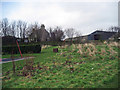
Auchterellon Farm
Looking toward the sheds and house from the adjoining park. The two swing sets have since been removed.
Image: © Alex Silver
Taken: 15 Feb 2007
0.06 miles