IMAGES TAKEN NEAR TO
Ness Circle, ELLON, AB41 9BR
Introduction
This page details the photographs taken nearby to Ness Circle, AB41 9BR by members of the Geograph project.
The Geograph project started in 2005 with the aim of publishing, organising and preserving representative images for every square kilometre of Great Britain, Ireland and the Isle of Man.

There are currently over 7.5m images from over14,400 individuals and you can help contribute to the project by visiting https://www.geograph.org.uk
Image Map
Images are licensed for reuse under creativecommons.org/licenses/by-sa/2.0
Notes
- Clicking on the map will re-center to the selected point.
- The higher the marker number, the further away the image location is from the centre of the postcode.
Image Listing (7 Images Found)
Images are licensed for reuse under creativecommons.org/licenses/by-sa/2.0
Image
Details
Distance
1
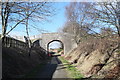
Bridge over the Formartine and Buchan Way
It appears to carry a farm track.
Image: © Bill Harrison
Taken: 23 Feb 2020
0.08 miles
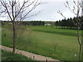
2
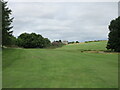
McDonald Golf Club, 2nd Hole, Par-Mac
The second hole at McDonald Golf Course in Ellon, looking to the green.
Image: © Scott Cormie
Taken: 28 Jul 2022
0.10 miles
3
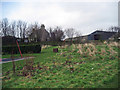
Auchterellon Farm
Looking toward the sheds and house from the adjoining park. The two swing sets have since been removed.
Image: © Alex Silver
Taken: 15 Feb 2007
0.17 miles
4
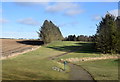
Fairway, McDonald Golf Club, Ellon...
...with farmland to the left.
Image: © Bill Harrison
Taken: 23 Feb 2020
0.17 miles
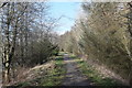
6
West edge of MacDonald Golf Course,Ellon
Path in foreground is part of Buchan and Formartine Rail Line Walkway
Image: © Ken Fitlike
Taken: 17 Apr 2007
0.22 miles
7
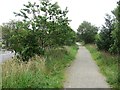
Formartine and Buchan Way
The trackbed of the Formartine and Buchan Railway, now a cycle path passes between a housing estate (left) and a golf course.
The Formartine and Buchan Railway is now a 80km path between Fraserburgh, Peterhead and Aberdeen. The railway closed in 1979 and was last used as part of the North Sea oil development, moving material up to Fraserburgh.
Image: © Richard Webb
Taken: 4 Aug 2011
0.25 miles