IMAGES TAKEN NEAR TO
Bruce Crescent, ELLON, AB41 9BF
Introduction
This page details the photographs taken nearby to Bruce Crescent, AB41 9BF by members of the Geograph project.
The Geograph project started in 2005 with the aim of publishing, organising and preserving representative images for every square kilometre of Great Britain, Ireland and the Isle of Man.

There are currently over 7.5m images from over14,400 individuals and you can help contribute to the project by visiting https://www.geograph.org.uk
Image Map
Images are licensed for reuse under creativecommons.org/licenses/by-sa/2.0
Notes
- Clicking on the map will re-center to the selected point.
- The higher the marker number, the further away the image location is from the centre of the postcode.
Image Listing (12 Images Found)
Images are licensed for reuse under creativecommons.org/licenses/by-sa/2.0
Image
Details
Distance
1
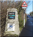
Welcome to Ellon...
...as seen by those arriving on the A920 from Oldmeldrum. The burgh arms: per fesse azure and pean three garbs or (granted 1935) pay tribute to the ancient arms of the Earl of Buchan and feature the very unusual tincture (colour) of 'pean', a heraldic fur consisting of "ermine spots of gold on a black field". The motto of "Judge notch quhill ye end" (don't count your chickens before they're hatched) comes from the Buchan and Kennedy family mottoes. Information on the arms came from the invaluable 'Scottish Burgh & County Heraldry' by R M Urquhart.
Image: © Bill Harrison
Taken: 1 Mar 2020
0.11 miles
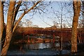
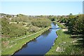
2
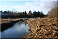
Banks of the Ythan
A frosty riverbank and islet on the Ythan at Ellon just west of the road bridge.
Image: © Andrew Wood
Taken: 30 Jan 2011
0.12 miles
3
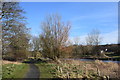
Riverside walk, Ellon...
...beside the River Ythan.
Image: © Bill Harrison
Taken: 1 Mar 2020
0.12 miles
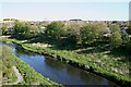
4
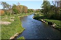
River Ythan
Looking downstream from the footbridge.
Image: © Anne Burgess
Taken: 11 May 2009
0.13 miles
5
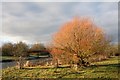
Tree by the Bridge
A riverbank tree by the Ythan with the Meklemill Footbridge in the background.
Image: © Andrew Wood
Taken: 30 Jan 2011
0.19 miles
6
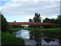
Footbridge over the Ythan
Footbridge over the river Ythan, Ellon
Image: © Derek Gray
Taken: 9 Jul 2008
0.19 miles
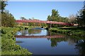
7
Meiklemill Footbridge
The footbridge linking Meiklemill to Modley in Ellon.
Image: © Andrew Wood
Taken: 9 Jan 2011
0.19 miles
8
Ythan Footbridge
This bridge provides a short route for students to make their way to school from the south bank of the river, where there has been a huge expansion of the town in recent decades.
Image: © Anne Burgess
Taken: 11 May 2009
0.20 miles
9
River Ythan
On the south (right) bank of the river is a large area of housing, none of which is on the 1976 1:50,000 map. This indicates how fast Ellon has grown in recent decades.
Image: © Anne Burgess
Taken: 11 May 2009
0.21 miles
10
River Ythan
Looking downstream from the former railway viaduct, which now carries the Formartine and Buchan Way, a long-distance walking and cycling route on the bed of the former railway.
Image: © Anne Burgess
Taken: 11 May 2009
0.24 miles