IMAGES TAKEN NEAR TO
Auchnagatt, ELLON, AB41 8UY
Introduction
This page details the photographs taken nearby to AB41 8UY by members of the Geograph project.
The Geograph project started in 2005 with the aim of publishing, organising and preserving representative images for every square kilometre of Great Britain, Ireland and the Isle of Man.

There are currently over 7.5m images from over14,400 individuals and you can help contribute to the project by visiting https://www.geograph.org.uk
Image Map
Images are licensed for reuse under creativecommons.org/licenses/by-sa/2.0
Notes
- Clicking on the map will re-center to the selected point.
- The higher the marker number, the further away the image location is from the centre of the postcode.
Image Listing (4 Images Found)
Images are licensed for reuse under creativecommons.org/licenses/by-sa/2.0
Image
Details
Distance
2
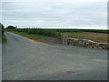
Entrance to Mains of Fortrie
One of the more impressive farm road ends in the district!
Image: © Ken Fitlike
Taken: 19 Jul 2007
0.12 miles
3
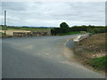
View north from Arnage school...
...towards the rolling fields of Mains of Fortrie. 'Fortrie' means 'front land', probably meaning an out-lying piece of ground belonging to a farm according to Celtic Placenames in Aberdeenshire by John Milne.
Image: © Bill Harrison
Taken: 16 May 2021
0.16 miles
4
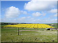
Milton of Coldwells
Looking north to Milton of Coldwells.
Image: © Scott Cormie
Taken: 21 Jun 2024
0.20 miles