IMAGES TAKEN NEAR TO
Auchnagatt, ELLON, AB41 8UU
Introduction
This page details the photographs taken nearby to AB41 8UU by members of the Geograph project.
The Geograph project started in 2005 with the aim of publishing, organising and preserving representative images for every square kilometre of Great Britain, Ireland and the Isle of Man.

There are currently over 7.5m images from over14,400 individuals and you can help contribute to the project by visiting https://www.geograph.org.uk
Image Map
Images are licensed for reuse under creativecommons.org/licenses/by-sa/2.0
Notes
- Clicking on the map will re-center to the selected point.
- The higher the marker number, the further away the image location is from the centre of the postcode.
Image Listing (2 Images Found)
Images are licensed for reuse under creativecommons.org/licenses/by-sa/2.0
Image
Details
Distance
1
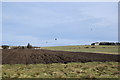
Aberdeenshire field-scape?
...as seen from the Formartine and Buchan Way. Blacksmith's Croft is centre left and farther back to the right is a barn associated with Upper Auquhadlie farm. According to Celtic Placenames in Aberdeenshire by John Milne, 'auquhadlie' means a grey field.
Image: © Bill Harrison
Taken: 29 Feb 2020
0.09 miles
2
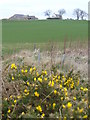
Waulkmill of Auchnagatt
Rich Buchan farmland seen from the Formartine & Buchan Way. The farm name is redolent of a former textile industry.
Image: © Colin Smith
Taken: 7 Apr 2007
0.23 miles