IMAGES TAKEN NEAR TO
ELLON, AB41 8PU
Introduction
This page details the photographs taken nearby to AB41 8PU by members of the Geograph project.
The Geograph project started in 2005 with the aim of publishing, organising and preserving representative images for every square kilometre of Great Britain, Ireland and the Isle of Man.

There are currently over 7.5m images from over14,400 individuals and you can help contribute to the project by visiting https://www.geograph.org.uk
Image Map
Images are licensed for reuse under creativecommons.org/licenses/by-sa/2.0
Notes
- Clicking on the map will re-center to the selected point.
- The higher the marker number, the further away the image location is from the centre of the postcode.
Image Listing (9 Images Found)
Images are licensed for reuse under creativecommons.org/licenses/by-sa/2.0
Image
Details
Distance
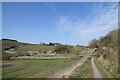
1
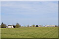
Distant view of Mains of Arnage...
...from the Formartine and Buchan Way.
Image: © Bill Harrison
Taken: 17 Apr 2021
0.01 miles
2
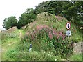
Missing bridge
Site of a bridge over a minor road just south of Arnage Station on the Formartine and Buchan Railway.
Image: © Richard Webb
Taken: 4 Aug 2011
0.14 miles
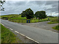
3
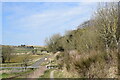
Crossing the road...
...on the Formartine and Buchan Way. The railway crossed over the minor road on a bridge, which has been demolished and the path now descends to cross the road.
Image: © Bill Harrison
Taken: 17 Apr 2021
0.16 miles
4
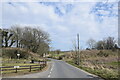
Crossing point...
...of the Formartine and Buchan Way and a minor road.
Image: © Bill Harrison
Taken: 17 Apr 2021
0.16 miles
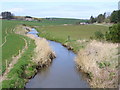
7
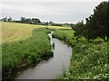
Ebrie Burn
Ebrie Burn upstream near Arnage Station.
Image: © Scott Cormie
Taken: 21 Jun 2024
0.20 miles
8
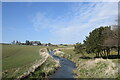
Valley of Ebrie Burn
'Ebrie' means muddy according to Celtic Placenames in Aberdeenshire by John Milne, although the water looks nice and blue on a sunny spring day.
Image: © Bill Harrison
Taken: 17 Apr 2021
0.21 miles
9
Ebrie Burn, Arnage
Looking north from the Mordon Road End. This side valley of the Ythan is mainly grazing land.
Image: © Colin Smith
Taken: 7 Apr 2007
0.24 miles