IMAGES TAKEN NEAR TO
Tipperty, ELLON, AB41 8LW
Introduction
This page details the photographs taken nearby to AB41 8LW by members of the Geograph project.
The Geograph project started in 2005 with the aim of publishing, organising and preserving representative images for every square kilometre of Great Britain, Ireland and the Isle of Man.

There are currently over 7.5m images from over14,400 individuals and you can help contribute to the project by visiting https://www.geograph.org.uk
Image Map
Images are licensed for reuse under creativecommons.org/licenses/by-sa/2.0
Notes
- Clicking on the map will re-center to the selected point.
- The higher the marker number, the further away the image location is from the centre of the postcode.
Image Listing (7 Images Found)
Images are licensed for reuse under creativecommons.org/licenses/by-sa/2.0
Image
Details
Distance
1
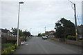
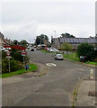
Tipperty village street
The main and only street in the ribbon-development village of dour pebbledash bungalows. Note the lack of pavements.
Image: © Bill Harrison
Taken: 27 Aug 2016
0.04 miles
2
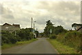
Tipperty
With the 20mph speed limit signs visible.
Image: © Steven Brown
Taken: 29 Jul 2007
0.05 miles
3
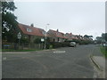
Logie Road, Tipperty
A handsome row of 1950's / 1960s Council houses.
Image: © Ken Fitlike
Taken: 21 Aug 2007
0.06 miles
4
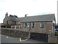
Tipperty School
There are still a fair number of traditional granite rural primary schools in Aberdeenshire.
Image: © Bill Harrison
Taken: 27 Aug 2016
0.09 miles
6
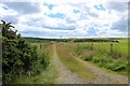
Track to Mill of Tarty
The back track to Mill of Tarty from Tipperty.
Image: © Andrew Wood
Taken: 19 Jul 2020
0.16 miles
7
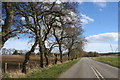
Cats Eyes Removed
The old A90 at Tipperty,with a new carriageway bypassing the farm this section was decommissioned and even the catseyes have been removed from the centreof the road.
Image: © Andrew Wood
Taken: 2 Apr 2011
0.22 miles