IMAGES TAKEN NEAR TO
ELLON, AB41 8JH
Introduction
This page details the photographs taken nearby to AB41 8JH by members of the Geograph project.
The Geograph project started in 2005 with the aim of publishing, organising and preserving representative images for every square kilometre of Great Britain, Ireland and the Isle of Man.

There are currently over 7.5m images from over14,400 individuals and you can help contribute to the project by visiting https://www.geograph.org.uk
Image Map
Images are licensed for reuse under creativecommons.org/licenses/by-sa/2.0
Notes
- Clicking on the map will re-center to the selected point.
- The higher the marker number, the further away the image location is from the centre of the postcode.
Image Listing (8 Images Found)
Images are licensed for reuse under creativecommons.org/licenses/by-sa/2.0
Image
Details
Distance
1
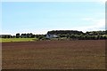
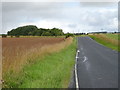
Mains Cottages
Mains of Waterton Cottages with the light green of a late sown crop in front and woodland behind. Mains of Waterton itself can be seen on the left rear.
Image: © Andrew Wood
Taken: 31 Aug 2020
0.01 miles
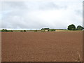
6
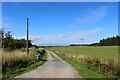
Mill Road
The access road to Mill of Auchmacoy.
Image: © Andrew Wood
Taken: 31 Aug 2020
0.19 miles
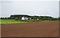
7
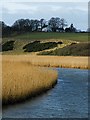
Mains of Waterton
Viewed across the Ythan Estuary reed beds from Logie Buchan Bridge.
Image: © Anne Burgess
Taken: 22 Feb 2009
0.21 miles
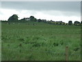
8
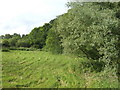
View north of Lintmill Bridge
By the road from Ellon to Denhead
Image: © Jonathan Billinger
Taken: 17 Jul 2007
0.25 miles