IMAGES TAKEN NEAR TO
Tarves, ELLON, AB41 7NJ
Introduction
This page details the photographs taken nearby to AB41 7NJ by members of the Geograph project.
The Geograph project started in 2005 with the aim of publishing, organising and preserving representative images for every square kilometre of Great Britain, Ireland and the Isle of Man.

There are currently over 7.5m images from over14,400 individuals and you can help contribute to the project by visiting https://www.geograph.org.uk
Image Map
Images are licensed for reuse under creativecommons.org/licenses/by-sa/2.0
Notes
- Clicking on the map will re-center to the selected point.
- The higher the marker number, the further away the image location is from the centre of the postcode.
Image Listing (9 Images Found)
Images are licensed for reuse under creativecommons.org/licenses/by-sa/2.0
Image
Details
Distance
1
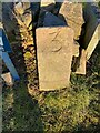
Old milestone
This simple stone is at the crossroads in Tarves where the B999 turns to the north. For the traveller from Aberdeen the 3 refers to the mileage to Haddo House, now National Trust for Scotland property but once the home of Lord Byron's mother, Catherine Gordon. It is marked on the pre 1900 OS 6" map as is the 1 mile stone on the route into the estate from the Mains of Keithfield. A 2 mile stone isn't marked.
Image: © Chris McBrien
Taken: 17 Feb 2021
0.02 miles
2
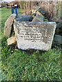
Commemorative stone & milestone
At the end of Duthie Road in Tarves where the B999 turns a right angle is this commemorative stone. Just round the corner can be seen a side view of the bevelled milestone 3 miles to Haddo House. The legend is 'This footpath has been formed/and the road widened/with money bequeathed by/the late William Duthie/ Collynie Tarves/1923.
Image: © Chris McBrien
Taken: 24 Feb 2021
0.02 miles
3
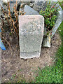
Milestone, Tarves, B999
At the crossroads of the B999 and Duthie Rd. Listed on the 1899/1901 map as MS Haddo House 3. see also Image
Inscription: 3
Milestone Society National ID: AD_HHAD03
Image: © Isla Taylor
Taken: 1 Sep 2021
0.03 miles
4
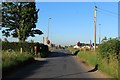
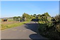
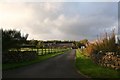
Road Junction
A road junction, effectively a crossroads, with a severe obstruction limiting visibility.
Image: © Andrew Wood
Taken: 25 Jun 2020
0.03 miles
5
Prenstone
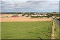
Beyond the fields at Prenstone, in the next square, are the outskirts of Tarves, almost all modern development.
Image: © Anne Burgess
Taken: 19 Sep 2008
0.13 miles
6
Braikley Farmhouse
The road to Braikley, signposted to the farmhouse this will lead to the farm too but the narrow nature would case heavy traffic to use the other entrance.
Image: © Andrew Wood
Taken: 25 Jun 2020
0.17 miles
7
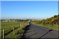
Road to Tarves
A look east towards Tarves, farmland either side of the road. Beyond lies Tarves and on the horizon, in the midst of trees, the Prop of Ythsie.
Image: © Andrew Wood
Taken: 25 Jun 2020
0.17 miles
8
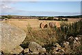
Braiklay
The farm buildings at Braiklay are among the trees at centre right. To the left, in the distance, are some of the large numbers of new houses which are threatening to overwhelm Tarves. The large boulder on the left is one of many, presumably cleared from the fields, dumped on the tumbledown drystane dyke.
Image: © Anne Burgess
Taken: 19 Sep 2008
0.20 miles
9
Braikley
Braikley Farm just outside Tarves.
Image: © Andrew Wood
Taken: 2 Oct 2008
0.22 miles