IMAGES TAKEN NEAR TO
Green Acres, ELLON, AB41 7NG
Introduction
This page details the photographs taken nearby to Green Acres, AB41 7NG by members of the Geograph project.
The Geograph project started in 2005 with the aim of publishing, organising and preserving representative images for every square kilometre of Great Britain, Ireland and the Isle of Man.

There are currently over 7.5m images from over14,400 individuals and you can help contribute to the project by visiting https://www.geograph.org.uk
Image Map
Images are licensed for reuse under creativecommons.org/licenses/by-sa/2.0
Notes
- Clicking on the map will re-center to the selected point.
- The higher the marker number, the further away the image location is from the centre of the postcode.
Image Listing (10 Images Found)
Images are licensed for reuse under creativecommons.org/licenses/by-sa/2.0
Image
Details
Distance
1
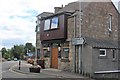
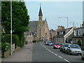
Pitmedden Bar
Located on the corner of Tarves road and Oldmeldrum this is a truly central as well as busy bar.
Image: © Andrew Wood
Taken: 19 Jul 2020
0.05 miles
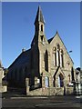
4
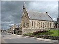
Pitmedden Parish Church
Built as the Free Kirk in the 1860s and B-listed: http://data.historic-scotland.gov.uk/pls/htmldb/f?p=2200:15:0::::BUILDING:19255 .
Image: © Bill Harrison
Taken: 14 Jun 2015
0.06 miles
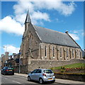
6
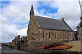
Pitmedden Kirk
Situated centrally in Pitmedden this is the parish church for Udny and Pitmedden.
Image: © Andrew Wood
Taken: 19 Jul 2020
0.07 miles
8
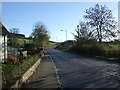
B9000 heading out of Pitmedden
Towards Newburgh.
Image: © JThomas
Taken: 10 Nov 2013
0.13 miles
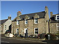
9
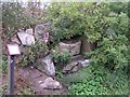
Grannies Steppies
Looking a lot more overgrown than the previous picture shown for this square
Image: © Karen Vernon
Taken: 7 Sep 2008
0.23 miles
10
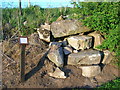
Grannie's Steppies near Pitmedden
At the SouthEast entrance to Pitmedden on the B999 lies the, locally known, "Grannie's Steppies" a small pile of stones.
It's thought that they may have once formed part of a stone circle that was situated on the fields behind, a favourable south/south west facing slope. A 1826 map shows a "burial mount" on the slope, semi-confirming the idea.
Other claim that they may have formed stepping stones over the local burn.
Image: © Ken Ross
Taken: 23 May 2007
0.25 miles