IMAGES TAKEN NEAR TO
Methlick, ELLON, AB41 7JD
Introduction
This page details the photographs taken nearby to AB41 7JD by members of the Geograph project.
The Geograph project started in 2005 with the aim of publishing, organising and preserving representative images for every square kilometre of Great Britain, Ireland and the Isle of Man.

There are currently over 7.5m images from over14,400 individuals and you can help contribute to the project by visiting https://www.geograph.org.uk
Image Map
Images are licensed for reuse under creativecommons.org/licenses/by-sa/2.0
Notes
- Clicking on the map will re-center to the selected point.
- The higher the marker number, the further away the image location is from the centre of the postcode.
Image Listing (9 Images Found)
Images are licensed for reuse under creativecommons.org/licenses/by-sa/2.0
Image
Details
Distance
7
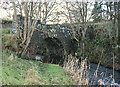
Old Bridge at Gight
The bridge carried the road over the Little Water, but has been replaced by a modern bridge just upstream. The buildings above are at Sunnyside.
Image: © Anne Burgess
Taken: 14 May 2009
0.19 miles
8
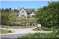
New House at Burnend of Gight
The original farm is further up the road to the left, among the trees. Taken from the bridge over the Little Water.
Image: © Anne Burgess
Taken: 14 May 2009
0.24 miles
9
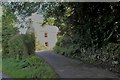
Waterside of Gight
Waterside with a narrow access and sheltering trees.
Image: © Andrew Wood
Taken: 31 Jul 2020
0.25 miles