IMAGES TAKEN NEAR TO
Udny, ELLON, AB41 6RU
Introduction
This page details the photographs taken nearby to AB41 6RU by members of the Geograph project.
The Geograph project started in 2005 with the aim of publishing, organising and preserving representative images for every square kilometre of Great Britain, Ireland and the Isle of Man.

There are currently over 7.5m images from over14,400 individuals and you can help contribute to the project by visiting https://www.geograph.org.uk
Image Map
Images are licensed for reuse under creativecommons.org/licenses/by-sa/2.0
Notes
- Clicking on the map will re-center to the selected point.
- The higher the marker number, the further away the image location is from the centre of the postcode.
Image Listing (7 Images Found)
Images are licensed for reuse under creativecommons.org/licenses/by-sa/2.0
Image
Details
Distance
1
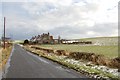
Rear end of Denend Cottages
Rear view from the south of Denend Cottages.
Image: © Scott Cormie
Taken: 28 May 2024
0.02 miles
2
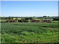
Clustered houses
An unusual group of houses, clustered in suburban style, but surrounded by open farmland.
Image: © John Allan
Taken: 6 Feb 2007
0.04 miles
3
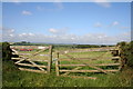
Gate by Denend
A field gate by Denend Cottages.
Image: © Andrew Wood
Taken: 8 Jun 2011
0.05 miles
4
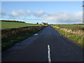
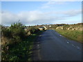
Country road heading west
Towards Bridgend.
Image: © JThomas
Taken: 10 Nov 2013
0.18 miles
5
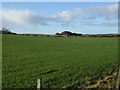
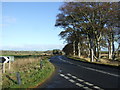
Farmland Denend
Off National Cycle Route 1.
Image: © JThomas
Taken: 10 Nov 2013
0.19 miles