IMAGES TAKEN NEAR TO
Udny, ELLON, AB41 6PU
Introduction
This page details the photographs taken nearby to AB41 6PU by members of the Geograph project.
The Geograph project started in 2005 with the aim of publishing, organising and preserving representative images for every square kilometre of Great Britain, Ireland and the Isle of Man.

There are currently over 7.5m images from over14,400 individuals and you can help contribute to the project by visiting https://www.geograph.org.uk
Image Map
Images are licensed for reuse under creativecommons.org/licenses/by-sa/2.0
Notes
- Clicking on the map will re-center to the selected point.
- The higher the marker number, the further away the image location is from the centre of the postcode.
Image Listing (4 Images Found)
Images are licensed for reuse under creativecommons.org/licenses/by-sa/2.0
Image
Details
Distance
1
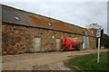
Mill of Torry Steading
Right on the roadside the working farm of Mill of Torry.
Image: © Andrew Wood
Taken: 14 Oct 2008
0.01 miles
2
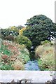
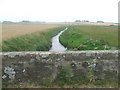
The Bronie
From the bridge at Mill of Torry the Brinie flowing to Esslemont.
Image: © Andrew Wood
Taken: 14 Oct 2008
0.03 miles
4
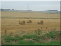
Fields at Mill of Torry Farm
Stripe Burn in mid-shot provides the drainage needed to keep the soil in good condition
Image: © Ken Fitlike
Taken: 21 Aug 2007
0.20 miles