IMAGES TAKEN NEAR TO
Kinmonth Road, STONEHAVEN, AB39 3YF
Introduction
This page details the photographs taken nearby to Kinmonth Road, AB39 3YF by members of the Geograph project.
The Geograph project started in 2005 with the aim of publishing, organising and preserving representative images for every square kilometre of Great Britain, Ireland and the Isle of Man.

There are currently over 7.5m images from over14,400 individuals and you can help contribute to the project by visiting https://www.geograph.org.uk
Image Map
Images are licensed for reuse under creativecommons.org/licenses/by-sa/2.0
Notes
- Clicking on the map will re-center to the selected point.
- The higher the marker number, the further away the image location is from the centre of the postcode.
Image Listing (25 Images Found)
Images are licensed for reuse under creativecommons.org/licenses/by-sa/2.0
Image
Details
Distance
1
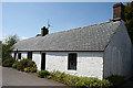
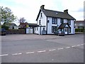
A Weaver's Cottage
This cottage is more or less unaltered externally, though it was probably thatched when first built.
Image: © Anne Burgess
Taken: 6 Jun 2013
0.05 miles
2
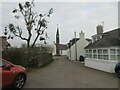
High Street
Looking east-ish from outside the gate of the Episcopal church.
Image: © Anne Burgess
Taken: 6 Jun 2013
0.08 miles
3
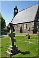
Episcopal Church
The church is no longer in use, but in a reasonable state of repair. It was built in 1863 to a design by Charles Brand, and the dedication is to St John the Baptist.
Image: © Anne Burgess
Taken: 6 Jun 2013
0.08 miles
4
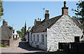
Kirk and Cottage
The belfry of the former Episcopal Church towers over a cottage at the end of the High Street.
Image: © Anne Burgess
Taken: 6 Jun 2013
0.08 miles
8
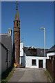
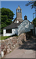
The Steeple
The free-standing steeple has nothing to do with calling the faithful to worship. Its bell used to signal the start and finish of the working day for the village's weavers, but these days the only time it is heard is to ring in the New Year.
It is said that the locals are so proud of their unusual steeple that they take it in when it rains. But I couldn't possibly comment.
Image: © Anne Burgess
Taken: 6 Jun 2013
0.10 miles
9
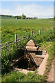
Harvey Well
The name is carved into the sandstone plinth, with the date 1887. It was the coldest of the six wells in the village, and the women of the village used to gather here to make butter. It stands beside the track to Nether Kinmonth.
Image: © Anne Burgess
Taken: 6 Jun 2013
0.10 miles
10
Drumlithie Steeple
Looking west along the High Street to Drumlithie Steeple bell tower.
Image: © Scott Cormie
Taken: 24 Apr 2022
0.10 miles