IMAGES TAKEN NEAR TO
Toucks Road, STONEHAVEN, AB39 3XX
Introduction
This page details the photographs taken nearby to Toucks Road, AB39 3XX by members of the Geograph project.
The Geograph project started in 2005 with the aim of publishing, organising and preserving representative images for every square kilometre of Great Britain, Ireland and the Isle of Man.

There are currently over 7.5m images from over14,400 individuals and you can help contribute to the project by visiting https://www.geograph.org.uk
Image Map
Images are licensed for reuse under creativecommons.org/licenses/by-sa/2.0
Notes
- Clicking on the map will re-center to the selected point.
- The higher the marker number, the further away the image location is from the centre of the postcode.
Image Listing (11 Images Found)
Images are licensed for reuse under creativecommons.org/licenses/by-sa/2.0
Image
Details
Distance
1
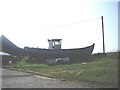
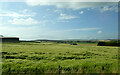
High and Dry
A boat by a house on the A92/A90 interchange.
Image: © Stanley Howe
Taken: 2 Jul 2009
0.04 miles
2
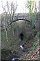
Glaslaw Bridge
Spanning the Glaslaw Burn.
Image: © Andrew Wood
Taken: 1 Mar 2011
0.13 miles
3
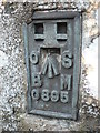
Flush Bracket OS marker
This flush bracket was used during the Second geodetic levelling,and was levelled with a height of 216.2030 feet
This bracket is facing away from the road over the arco barrier not easy to find
Flush Bracket # 39
Image: © Liz Gray
Taken: 16 Oct 2011
0.15 miles
4
Glaslaw Bridge
Glaslaw Bridge by the A957
Image: © Shaun Ferguson
Taken: 3 Jun 2010
0.16 miles
6
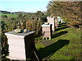
Bee Hives
Good use of an old road. This is so close to a major road but you would never find this little hive of industry unless you got out exploring
Image: © Liz Gray
Taken: 16 Oct 2011
0.18 miles
7
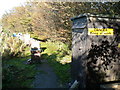
Warning Sign
A sign you would be well advised to pay attention to
Image: © Liz Gray
Taken: 16 Oct 2011
0.19 miles
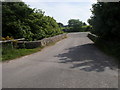
8
Footbridge by the Bath
A footbridge by Lady Kennedy's Bath.
Image: © Andrew Wood
Taken: 1 Mar 2011
0.22 miles
9
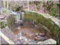
Lady Kennedy's Bath, Dunnottar Woods, Stonehaven
This is an oval-shaped stone-built structure said to be the remains of the bathing place of the local laird's wife. See http://www.mearns.org.uk/stonehaven/famelady.htm
Image: © Lloyd Housley
Taken: 7 Mar 2004
0.22 miles
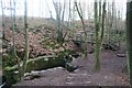
10
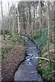
Burn of Glaslaw
The Burn of Glaslaw flowing through Dunnottar Woods.
Image: © Andrew Wood
Taken: 1 Mar 2011
0.22 miles