IMAGES TAKEN NEAR TO
STONEHAVEN, AB39 3US
Introduction
This page details the photographs taken nearby to AB39 3US by members of the Geograph project.
The Geograph project started in 2005 with the aim of publishing, organising and preserving representative images for every square kilometre of Great Britain, Ireland and the Isle of Man.

There are currently over 7.5m images from over14,400 individuals and you can help contribute to the project by visiting https://www.geograph.org.uk
Image Map
Images are licensed for reuse under creativecommons.org/licenses/by-sa/2.0
Notes
- Clicking on the map will re-center to the selected point.
- The higher the marker number, the further away the image location is from the centre of the postcode.
Image Listing (7 Images Found)
Images are licensed for reuse under creativecommons.org/licenses/by-sa/2.0
Image
Details
Distance
1
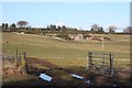
Looking towards West Cheyne
A muddy gateway links fields at Blairs, with new houses at West Cheyne in the background.
Image: © Anne Burgess
Taken: 1 Mar 2010
0.04 miles
2
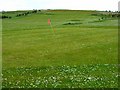
Cheyne Golf Course
Top end of the course. http://www.uk-golfguide.com/scotland/26604.html
Image: © Oliver Dixon
Taken: 27 May 2006
0.13 miles
3
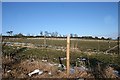
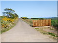
Fences on Cheyne Hill
Several new fences have been constructed in these fields on Cheyne Hill. Note how little snow is still lying here, less than a kilometre and just a few minutes from Image
Image: © Anne Burgess
Taken: 1 Mar 2010
0.19 miles
4
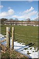
Near Blairs
The grassy fields are almost clear of the snow, but there is still some lying on the ploughed fields.
Image: © Anne Burgess
Taken: 2 Apr 2010
0.22 miles
6
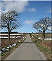
Cheyne Hill from Blairs
Looking up the slope from just north of Blairs towards the road junction at the top of the brae.
Image: © Anne Burgess
Taken: 2 Apr 2010
0.23 miles
7
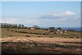
Nether Cheyne
Looking across the fields from Blairs towards Nether Cheyne, which is just inside the same square.
Image: © Anne Burgess
Taken: 1 Mar 2010
0.23 miles