IMAGES TAKEN NEAR TO
Villagelands Road, STONEHAVEN, AB39 3UN
Introduction
This page details the photographs taken nearby to Villagelands Road, AB39 3UN by members of the Geograph project.
The Geograph project started in 2005 with the aim of publishing, organising and preserving representative images for every square kilometre of Great Britain, Ireland and the Isle of Man.

There are currently over 7.5m images from over14,400 individuals and you can help contribute to the project by visiting https://www.geograph.org.uk
Image Map
Images are licensed for reuse under creativecommons.org/licenses/by-sa/2.0
Notes
- Clicking on the map will re-center to the selected point.
- The higher the marker number, the further away the image location is from the centre of the postcode.
Image Listing (31 Images Found)
Images are licensed for reuse under creativecommons.org/licenses/by-sa/2.0
Image
Details
Distance
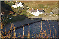
1
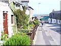
Hillhead Road, Newtonhill
The main street of the village still has many old cottages. The former fishing village is now a dormitory village for Aberdeen.
Image: © Colin Smith
Taken: 5 Aug 2009
0.07 miles
2
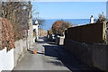
Newtonhill: walking to the harbour
The cat was friendly...
Image: © Bill Harrison
Taken: 24 Mar 2018
0.07 miles
3
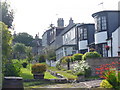
Whitelands Road, Newtonhill
Interesting mix of architectural styles in this residential road leading away from the clifftop.
Image: © Colin Smith
Taken: 5 Aug 2009
0.09 miles
4
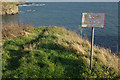
Cliffs at Newtonhill
The sign may be decrepit, but it is certainly wise to heed its warning.
Image: © Stephen McKay
Taken: 7 Nov 2010
0.11 miles
5
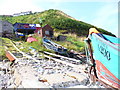
Boat Winches, Newtonhill
The small fishing boats must be winched up the cobbled beach from the water to the huts well above the high water mark.
Image: © Colin Smith
Taken: 5 Aug 2009
0.13 miles
6
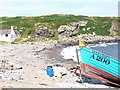
Newtonhill Bay
A small half moon-shaped bay where small fishing boats are still winched up out of the water onto the cobbles.
Image: © Colin Smith
Taken: 5 Aug 2009
0.14 miles
7
Newtonhill Bay
Looking down at this rocky cove from the cliffs above.
Image: © Stephen McKay
Taken: 7 Nov 2010
0.14 miles
8
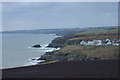
South from the Cran Hill
Looking south from the slopes of the Cran Hill, the rugged nature of the east coast of Scotland can be seen clearly in this photograph. The village on the headland is the lower part of Newtonhill, or perhaps Skateraw, the old name for this village. In the distance, someone with a keen eye and a good knowledge of the area might just be able to discern where the Highland Fault Line ends, near Stonehaven. I can't!
Image: © Iain Millar
Taken: 27 Dec 2005
0.14 miles
9
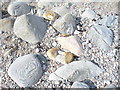
Cobbles and Rocks on Newtonhill Beach
The rocks have been rounded by rolling under wave action and show their strata in the ring patterns.
Image: © Colin Smith
Taken: 5 Aug 2009
0.14 miles
10
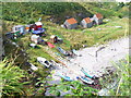
Boat Huts, Newtonhill
A collection of small wooden huts sit above the cobbly beach. The fishing boats are winched out of the water and up the beach to the huts.
Image: © Colin Smith
Taken: 5 Aug 2009
0.15 miles