IMAGES TAKEN NEAR TO
Garron Lane, STONEHAVEN, AB39 3UG
Introduction
This page details the photographs taken nearby to Garron Lane, AB39 3UG by members of the Geograph project.
The Geograph project started in 2005 with the aim of publishing, organising and preserving representative images for every square kilometre of Great Britain, Ireland and the Isle of Man.

There are currently over 7.5m images from over14,400 individuals and you can help contribute to the project by visiting https://www.geograph.org.uk
Image Map
Images are licensed for reuse under creativecommons.org/licenses/by-sa/2.0
Notes
- Clicking on the map will re-center to the selected point.
- The higher the marker number, the further away the image location is from the centre of the postcode.
Image Listing (11 Images Found)
Images are licensed for reuse under creativecommons.org/licenses/by-sa/2.0
Image
Details
Distance
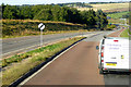
3
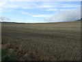
Stubble field, New Mains of Ury
National Cycle Route 1.
Image: © JThomas
Taken: 8 Nov 2013
0.11 miles
5
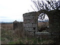
Boundary wall
Relic of former boundary wall to Ury House estate, by New Mains of Ury cottages. Another lodge gate perhaps?
Image: © Stanley Howe
Taken: 14 Mar 2007
0.16 miles
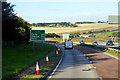
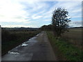
7
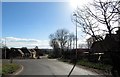
New Mains of Ury, Stonehaven
Dog-leg bend in B979; new dwellings development ahead, entrance to Ury Estate on right.
Image: © Stanley Howe
Taken: 29 Mar 2019
0.22 miles