IMAGES TAKEN NEAR TO
Cranhill Brae, STONEHAVEN, AB39 3TJ
Introduction
This page details the photographs taken nearby to Cranhill Brae, AB39 3TJ by members of the Geograph project.
The Geograph project started in 2005 with the aim of publishing, organising and preserving representative images for every square kilometre of Great Britain, Ireland and the Isle of Man.

There are currently over 7.5m images from over14,400 individuals and you can help contribute to the project by visiting https://www.geograph.org.uk
Image Map
Images are licensed for reuse under creativecommons.org/licenses/by-sa/2.0
Notes
- Clicking on the map will re-center to the selected point.
- The higher the marker number, the further away the image location is from the centre of the postcode.
Image Listing (30 Images Found)
Images are licensed for reuse under creativecommons.org/licenses/by-sa/2.0
Image
Details
Distance
1
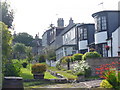
Whitelands Road, Newtonhill
Interesting mix of architectural styles in this residential road leading away from the clifftop.
Image: © Colin Smith
Taken: 5 Aug 2009
0.06 miles
2
Newtonhill: walking to the harbour
The cat was friendly...
Image: © Bill Harrison
Taken: 24 Mar 2018
0.08 miles
4
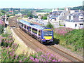
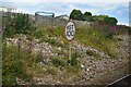
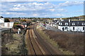
Railway Line at Newtonhill
Passenger train heading south from Aberdeen to Glasgow, passing through Newtonhill.
Image: © Colin Smith
Taken: 5 Aug 2009
0.08 miles
6
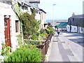
Hillhead Road, Newtonhill
The main street of the village still has many old cottages. The former fishing village is now a dormitory village for Aberdeen.
Image: © Colin Smith
Taken: 5 Aug 2009
0.09 miles
7
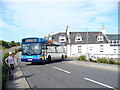
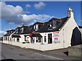
Old Mill Road, Newtonhill
At the junction with Hillhead Road where the buses pick up and drop off passengers in Newtonhill village centre. The bus is on the local Aberdeen-Stonehaven service. The railway line is to left, off picture.
Image: © Colin Smith
Taken: 5 Aug 2009
0.09 miles
8
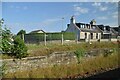
Site of Newtonhill Station
The station closed in 1956 although there is some talk of reopening it as Newtonhill has transformed from a fishing village to a commuter settlement. Compare the photo from 2009 http://www.geograph.org.uk/photo/1454732 for changes to track layout and signals.
Image: © Bill Harrison
Taken: 24 Mar 2018
0.10 miles
9

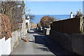
Newtonhill
Looking across the gully of the Burn of Elsick to the village, which stands on the clifftop.
Image: © Anne Burgess
Taken: 19 Jun 2009
0.10 miles