IMAGES TAKEN NEAR TO
Marine View, STONEHAVEN, AB39 3TG
Introduction
This page details the photographs taken nearby to Marine View, AB39 3TG by members of the Geograph project.
The Geograph project started in 2005 with the aim of publishing, organising and preserving representative images for every square kilometre of Great Britain, Ireland and the Isle of Man.

There are currently over 7.5m images from over14,400 individuals and you can help contribute to the project by visiting https://www.geograph.org.uk
Image Map
Images are licensed for reuse under creativecommons.org/licenses/by-sa/2.0
Notes
- Clicking on the map will re-center to the selected point.
- The higher the marker number, the further away the image location is from the centre of the postcode.
Image Listing (17 Images Found)
Images are licensed for reuse under creativecommons.org/licenses/by-sa/2.0
Image
Details
Distance
1
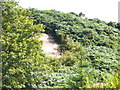
Peace 1919
Commemorative plaque on a hillock on the east side of the railway line in Muchalls. It is in need of better exposure by cutting back the bracken on the hillock.
Image: © Colin Smith
Taken: 5 Aug 2009
0.08 miles
2
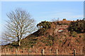
Peace memorial, Muchalls
A mosaic of tesserae in earth colours showing a royal crown and the word 'PEACE' above with the date '1919' below, set in a shield of pinkish concrete. Most unusual among war memorials in actually celebrating peace as opposed to commemorating war.
Image: © Colin Kinnear
Taken: 2 Mar 2011
0.08 miles
4
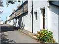
Marine Terrace, Muchalls
The row of old cottages (formerly coastguard houses) have their doors and a wall of stone looking onto the village street - but their main aspect must be the other side, overlooking the sea.
Image: © Colin Smith
Taken: 5 Aug 2009
0.15 miles

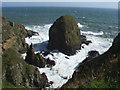
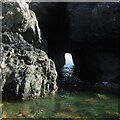
7
Arch at the end of an inlet at Grum Briggs
The Ordnance Survey Namebook entry for Grum Briggs is:
"A rocky peninsula situated on the south side of Grum Haven. The sea has formed a large passage through the cliff at the narrow rock joining the peninsula with the main land." Kincardineshire, Fetteresso, p85
The image shows that "large passage" or arch at the end of the inlet. It may help to zoom the image because beyond the pebble beach is a pile of grassed over debris which makes it bit tricky to make out the outline. Just to the left is sunlight coming through another arch just on this side of the first arch.
Image: © Nigel Feilden
Taken: 6 Nov 2020
0.20 miles
8
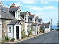
Cottages in Muchalls
Row of attractive cottages in the heugh-head former fishing village of Muchalls. Muchalls is now mainly a dormitory village for Aberdeen.
Image: © Colin Smith
Taken: 5 Aug 2009
0.20 miles
9
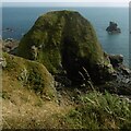
Douniefell with west entrance to Ship Hole
This is a nearly stack/island which is part of the intertidal area below Seacliff, Muchalls. The entry to Ship Hole - shown as a subterranean passage on the 1902 version of the 25 in/mile OS - about central, but in shadow.
The top of Douniefell is a Canmore site 37225 'enclosure', undated so far.
Image and Image show it from the south. It is a bit easier to spot in the latter, in which its shadow on the cliff to the east (this camera location) makes it easier to pick out. See also the oblique aerial view from the north on Canmore.
Image: © Nigel Feilden
Taken: 27 Aug 2019
0.22 miles
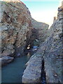
10
Looking through Ship Hole
This tunnel runs under Douniefell - see Image - and is 33m long.
According to the OS namebook, a ship was wrecked at the sea end of this, some time before it was published ca 1870.
Image: © Nigel Feilden
Taken: 27 Aug 2019
0.22 miles