IMAGES TAKEN NEAR TO
Market Lane, STONEHAVEN, AB39 2FW
Introduction
This page details the photographs taken nearby to Market Lane, AB39 2FW by members of the Geograph project.
The Geograph project started in 2005 with the aim of publishing, organising and preserving representative images for every square kilometre of Great Britain, Ireland and the Isle of Man.

There are currently over 7.5m images from over14,400 individuals and you can help contribute to the project by visiting https://www.geograph.org.uk
Image Map
Images are licensed for reuse under creativecommons.org/licenses/by-sa/2.0
Notes
- Clicking on the map will re-center to the selected point.
- The higher the marker number, the further away the image location is from the centre of the postcode.
Image Listing (205 Images Found)
Images are licensed for reuse under creativecommons.org/licenses/by-sa/2.0
Image
Details
Distance
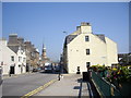
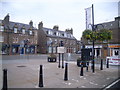
1
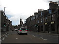
A street scene in Stonehaven
With the Market Buildings dominating.
Image: © James Denham
Taken: 30 Jul 2012
0.02 miles
2
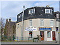
The Carron Fish Bar, Stonehaven
This shop used to be called "The Haven" but today it is world renowned for being the birthplace of the deep-fried Mars Bar. Behind it are more traditional red sandstone buildings on the banks of the River Carron.
Image: © Colin Smith
Taken: 10 Apr 2007
0.02 miles
3
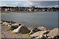
Stonehaven
This is the view across the bay from beside the car park at the harbour.
Image: © Anne Burgess
Taken: 11 Sep 2019
0.02 miles
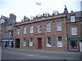
4
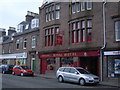
Royal Hotel, Stonehaven
44 Allardice Street.
Image: © Nick Mutton 01329 000000
Taken: 17 Aug 2008
0.02 miles
5
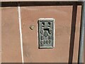
Ordnance Survey Flush Bracket G897
This bracket can be found on the wall of the Town Hall, Stonehaven.
The recorded details give a height of 5.5802 metres above sea level.
For more details see : https://www.bench-marks.org.uk/bm357
Image: © Peter Wood
Taken: 12 Aug 2021
0.02 miles
7
Allardice Street (A957)
From the bridge over Carron Water.
Image: © Stanley Howe
Taken: 2 Jul 2009
0.03 miles
8
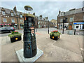
Light the North trail
The Light the North lighthouse trail took people on a cultural tour of the north-east of Scotland, including Moray, Orkney and Shetland. Visitors discovered over 45 lighthouse sculptures designed and created by some of the area’s most talented artists.
The trail raised awareness and funds for the most significant cancer support charity in the region, CLAN Cancer Support. The charity shined a light of hope in the dark for anyone affected by cancer.
Image: © Ralph Greig
Taken: 27 Aug 2021
0.03 miles
10
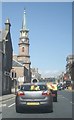
Traffic lights in Stonehaven
A957 turns left here, from Allardice Street into Evan Street. The clock tower is on the town hall in the market place.
Image: © Stanley Howe
Taken: 6 Jun 2013
0.03 miles