IMAGES TAKEN NEAR TO
Craigellachie, ABERLOUR, AB38 9SD
Introduction
This page details the photographs taken nearby to AB38 9SD by members of the Geograph project.
The Geograph project started in 2005 with the aim of publishing, organising and preserving representative images for every square kilometre of Great Britain, Ireland and the Isle of Man.

There are currently over 7.5m images from over14,400 individuals and you can help contribute to the project by visiting https://www.geograph.org.uk
Image Map
Images are licensed for reuse under creativecommons.org/licenses/by-sa/2.0
Notes
- Clicking on the map will re-center to the selected point.
- The higher the marker number, the further away the image location is from the centre of the postcode.
Image Listing (6 Images Found)
Images are licensed for reuse under creativecommons.org/licenses/by-sa/2.0
Image
Details
Distance
1
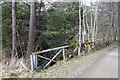
Bridge of Lodges
A rustic handrail, presumably surviving from the heyday of Wester Elchies.
Image: © Anne Burgess
Taken: 22 Mar 2021
0.06 miles
2
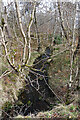
Burn of Blackfolds
Looking downstream from the Bridge of Lodges.
Image: © Anne Burgess
Taken: 22 Mar 2021
0.06 miles
3
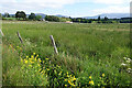
Boggy Land near Darglins
A dense patch of rushes, and Monkeyflower growing in the ditch, reveal that this field must be pretty wet ground.
Image: © Anne Burgess
Taken: 29 Jun 2021
0.16 miles
4
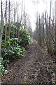
Former Drive
This was the drive from Bridge of Lodges to Wester Elchies House. It must have been maintained and kept free of encroaching vegetation during the half-century since the house was demolished.
Image: © Anne Burgess
Taken: 22 Mar 2021
0.18 miles
5
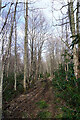
The Wilderness
The Wilderness is a semi-wild area north of the site of Wester Elchies House, which was demolished in the late 1960s. The drive linked the house and the Bridge of Lodges, and it seems to have been maintained to prevent encroachment by vegetation.
Image: © Anne Burgess
Taken: 22 Mar 2021
0.22 miles
6
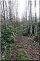
Rhododendron ponticum
The rhododendrons look wonderful when covered with flowers in early summer, but they are an invasive menace, shading out everything else that might try to grow underneath them. This is a stretch of the former drive between the site of Wester Elchies House and the Bridge of Lodges.
Image: © Anne Burgess
Taken: 22 Mar 2021
0.24 miles